Economy night lights from space
Night Light of Economy (Pennsylvania) from space (United States) Src. Average luminocity for 10x10km area is 49.4724% and for 50x50km: 36.1%.
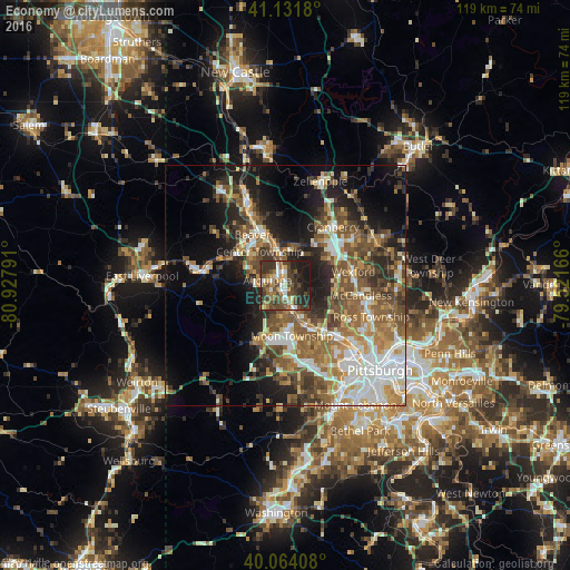
Analysis of Economy night lights 2016
Square area 10x10 km:
 5.19%
5.19%90-99
7.47%80-89
4.55%70-79
4.22%60-69
10.55%50-59
7.63%40-49
19.32%30-39
15.1%20-29
14.45%10-19
11.53%0-9
0%Square area 50x50 km:
5.9%90-99
6.12%80-89
4.04%70-79
4.38%60-69
5.97%50-59
7.6%40-49
7.23%30-39
5.14%20-29
7.71%10-19
12.87%0-9
33.05%Clear (daylight) street map image can be seen on geolist.org.
Map coordinates:
41° 7' 54.5" North, 80° 55' 40.5" West
40° 36' 0.3" North, 80° 13' 29.2" West
40° 3' 50.7" North, 79° 31' 18" West
Some cities around Economy sort by population:
• Cranberry Township
13.7 km =8.5 mi,  46°
46°
• Franklin Park
11.7 km =7.3 mi,  99°
99°
• Fernway
13.2 km =8.2 mi,  36°
36°
• Carnot-Moon
9.1 km =5.7 mi,  176°
176°
• Aliquippa
4.3 km =2.7 mi,  342°
342°
• Ambridge
1.2 km =0.7 mi, 181°
• Monaca
10.5 km =6.5 mi, 337°
• Coraopolis
10.3 km =6.4 mi,  151°
151°
5188236 (p: 9,363)
Sources (retrieved 2019-11-25):
» Earth at Night: Flat Maps 2012, 2016