Naranja night lights from space
Night Light of Naranja (Florida) from space (United States) Src. Average luminocity for 10x10km area is 81.3413% and for 50x50km: 28.4053%.
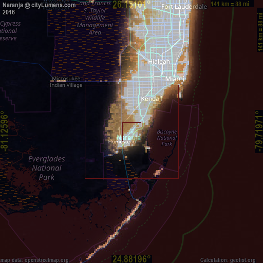
Analysis of Naranja night lights 2016
Square area 10x10 km:
 20.04%
90-99
23.61%80-89
8.73%70-79
12.9%60-69
27.18%50-59
4.76%40-49
2.38%30-39
0.4%20-29
0%10-19
0%0-9
0%Square area 50x50 km:
8.85%90-99
5.91%80-89
1.96%70-79
1.37%60-69
7.38%50-59
3.92%40-49
2.92%30-39
2.41%20-29
3.09%10-19
6.3%0-9
55.89%Clear (daylight) street map image can be seen on geolist.org.
Map coordinates:
26° 9' 3.6" North, 81° 7' 33.5" West
25° 31' 5.4" North, 80° 25' 22.2" West
24° 52' 55.1" North, 79° 43' 11" West
Some cities around Naranja sort by population:
• Homestead
7.8 km =4.8 mi,  224°
224°
• South Miami Heights
9.8 km =6.1 mi,  25°
25°
• Richmond West
10.3 km =6.4 mi,  356°
356°
• Cutler Ridge
10.3 km =6.4 mi,  47°
47°
• Leisure City
2.6 km =1.6 mi,  194°
194°
• Princeton
2.7 km =1.7 mi, 31°
• Florida City
9.6 km =6 mi, 215°
• Goulds
6.4 km =4 mi,  39°
39°
4165580 (p: 8,303)
Sources (retrieved 2019-11-25):
» Earth at Night: Flat Maps 2012, 2016