Exeter night lights from space
Night Light of Exeter (Pennsylvania) from space (United States) Src. Average luminocity for 10x10km area is 52.8759% and for 50x50km: 18.0826%.
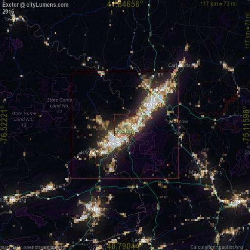
Analysis of Exeter night lights 2016
Square area 10x10 km:
 2.89%
2.89%90-99
5.1%80-89
7.82%70-79
17.86%60-69
7.82%50-59
18.88%40-49
7.99%30-39
5.1%20-29
10.71%10-19
12.93%0-9
2.89%Square area 50x50 km:
2.57%90-99
2.8%80-89
1.99%70-79
2.34%60-69
2.78%50-59
2.97%40-49
2.62%30-39
3.22%20-29
6.33%10-19
9.49%0-9
62.9%Clear (daylight) street map image can be seen on geolist.org.
Map coordinates:
41° 50' 47.6" North, 76° 31' 20" West
41° 19' 14.3" North, 75° 49' 8.7" West
40° 47' 25.6" North, 75° 6' 57.5" West
Some cities around Exeter sort by population:
• Wilkes-Barre
9.8 km =6.1 mi,  212°
212°
• Back Mountain
14.9 km =9.3 mi,  276°
276°
• Kingston
9.2 km =5.7 mi,  224°
224°
• Old Forge
9 km =5.6 mi,  51°
51°
• Pittston
2.5 km =1.6 mi,  76°
76°
• Taylor
12.5 km =7.8 mi, 48°
• Plymouth
13.8 km =8.6 mi,  229°
229°
• Moosic
7.7 km =4.8 mi,  61°
61°
5189004 (p: 5,596)
Sources (retrieved 2019-11-25):
» Earth at Night: Flat Maps 2012, 2016