Matawan night lights from space
Night Light of Matawan (New Jersey) from space (United States) Src. Average luminocity for 10x10km area is 68.3605% and for 50x50km: 61.9005%.
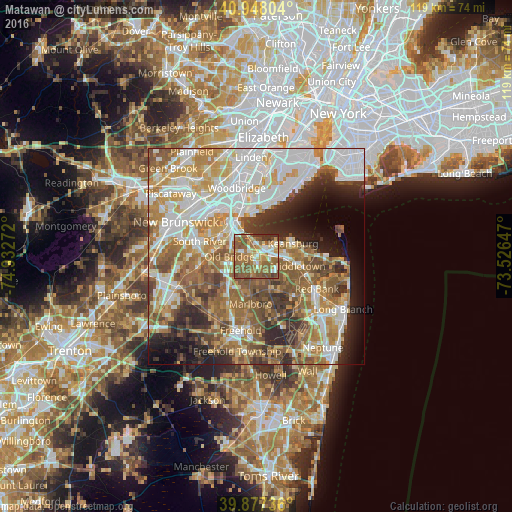
Analysis of Matawan night lights 2016
Square area 10x10 km:
 7.99%
7.99%90-99
11.56%80-89
7.99%70-79
12.93%60-69
19.73%50-59
29.25%40-49
5.1%30-39
4.59%20-29
0.85%10-19
0%0-9
0%Square area 50x50 km:
15.05%90-99
13.34%80-89
7.56%70-79
9.13%60-69
10.96%50-59
10.81%40-49
6.17%30-39
5.77%20-29
7.49%10-19
6.27%0-9
7.44%Clear (daylight) street map image can be seen on geolist.org.
Map coordinates:
40° 56' 52.9" North, 74° 55' 57.8" West
40° 24' 53.4" North, 74° 13' 46.5" West
39° 52' 38.5" North, 73° 31' 35.3" West
Some cities around Matawan sort by population:
• Keansburg
9 km =5.6 mi,  70°
70°
• South Amboy
8.7 km =5.4 mi,  323°
323°
• Strathmore
2.5 km =1.6 mi,  146°
146°
• Keyport
3.3 km =2.1 mi,  51°
51°
• Madison Park
7.8 km =4.8 mi,  301°
301°
• Laurence Harbor
4.9 km =3 mi,  342°
342°
• Union Beach
5.6 km =3.5 mi, 51°
• Morganville
4.4 km =2.7 mi,  196°
196°
5100940 (p: 8,853)
Sources (retrieved 2019-11-25):
» Earth at Night: Flat Maps 2012, 2016