Lucerne Valley night lights from space
Night Light of Lucerne Valley (California) from space (United States) Src. Average luminocity for 10x10km area is 2.4056% and for 50x50km: 3.982%.
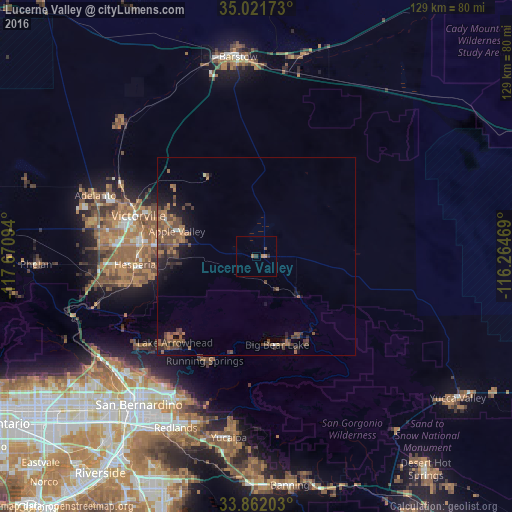
Analysis of Lucerne Valley night lights 2016
Square area 10x10 km:
 0%
0%90-99
0%80-89
0%70-79
0.52%60-69
1.57%50-59
0%40-49
0.7%30-39
1.22%20-29
0.17%10-19
0%0-9
95.8%Square area 50x50 km:
0.03%90-99
0.11%80-89
0.08%70-79
0.17%60-69
1.35%50-59
1.11%40-49
1.91%30-39
0.91%20-29
0.8%10-19
2.64%0-9
90.87%Clear (daylight) street map image can be seen on geolist.org.
Map coordinates:
35° 1' 18.2" North, 117° 40' 15.4" West
34° 26' 38" North, 116° 58' 4.1" West
33° 51' 43.3" North, 116° 15' 52.9" West
Some cities around Lucerne Valley sort by population:
• Victorville
31.4 km =19.5 mi,  289°
289°
• Hesperia
30.6 km =19 mi,  266°
266°
• Apple Valley
21 km =13 mi, 287°
• Lake Arrowhead
29.8 km =18.5 mi,  223°
223°
• Big Bear City
23.2 km =14.4 mi,  150°
150°
• Crestline
36.8 km =22.9 mi,  232°
232°
• Spring Valley Lake
28.1 km =17.5 mi,  281°
281°
• Big Bear Lake
22.8 km =14.2 mi,  166°
166°
5369150 (p: 5,811)
Sources (retrieved 2019-11-25):
» Earth at Night: Flat Maps 2012, 2016