Kingston night lights from space
Night Light of Kingston (Tennessee) from space (United States) Src. Average luminocity for 10x10km area is 38.7161% and for 50x50km: 15.1984%.
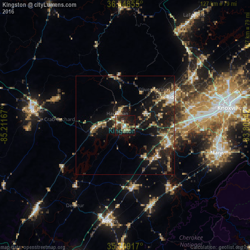
Analysis of Kingston night lights 2016
Square area 10x10 km:
 2.2%
2.2%90-99
4.03%80-89
7.88%70-79
4.76%60-69
7.14%50-59
5.13%40-49
6.78%30-39
11.54%20-29
13%10-19
33.15%0-9
4.4%Square area 50x50 km:
1.05%90-99
1.35%80-89
2.49%70-79
1.72%60-69
2.09%50-59
2.62%40-49
2.28%30-39
3.84%20-29
5.06%10-19
14.65%0-9
62.86%Clear (daylight) street map image can be seen on geolist.org.
Map coordinates:
36° 26' 54.8" North, 85° 12' 42" West
35° 52' 51.3" North, 84° 30' 30.7" West
35° 18' 33" North, 83° 48' 19.5" West
Some cities around Kingston sort by population:
• Oak Ridge
25.9 km =16.1 mi,  56°
56°
• Farragut
32 km =19.9 mi,  89°
89°
• Lenoir City
24.6 km =15.3 mi,  112°
112°
• Harriman
7.1 km =4.4 mi,  326°
326°
• Sweetwater
31.4 km =19.5 mi,  172°
172°
• Tellico Village
31.7 km =19.7 mi,  133°
133°
• Loudon
22.8 km =14.2 mi,  136°
136°
• Rockwood
16 km =9.9 mi,  263°
263°
4634671 (p: 5,846)
Sources (retrieved 2019-11-25):
» Earth at Night: Flat Maps 2012, 2016