Long Beach night lights from space
Night Light of Long Beach (Mississippi) from space (United States) Src. Average luminocity for 10x10km area is 55.9304% and for 50x50km: 23.6641%.
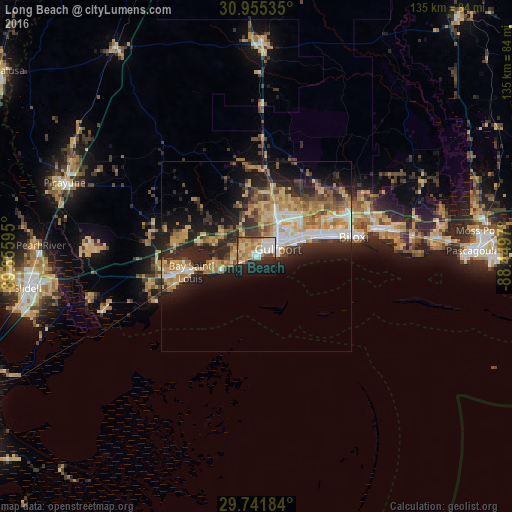
Analysis of Long Beach night lights 2016
Square area 10x10 km:
 9.52%
9.52%90-99
11.36%80-89
10.99%70-79
10.44%60-69
11.54%50-59
3.66%40-49
3.3%30-39
2.01%20-29
16.48%10-19
18.86%0-9
1.83%Square area 50x50 km:
2.87%90-99
3.19%80-89
4.55%70-79
3.98%60-69
4.49%50-59
2.69%40-49
2.69%30-39
3.65%20-29
8.35%10-19
10.52%0-9
53.03%Clear (daylight) street map image can be seen on geolist.org.
Map coordinates:
30° 57' 19.3" North, 89° 51' 21.4" West
30° 21' 1.7" North, 89° 9' 10.2" West
29° 44' 30.6" North, 88° 26' 58.9" West
Some cities around Long Beach sort by population:
• Gulfport
6.1 km =3.8 mi,  71°
71°
• West Gulfport
8.2 km =5.1 mi,  43°
43°
• Biloxi
26.2 km =16.3 mi,  78°
78°
• D'Iberville
26.5 km =16.5 mi, 71°
• Bay Saint Louis
17.6 km =10.9 mi,  254°
254°
• Diamondhead
20.8 km =12.9 mi,  283°
283°
• Waveland
22.6 km =14 mi, 251°
• Pass Christian
9.9 km =6.2 mi, 246°
4434069 (p: 15,555)
Sources (retrieved 2019-11-25):
» Earth at Night: Flat Maps 2012, 2016