Bay Saint Louis night lights from space
Night Light of Bay Saint Louis (Mississippi) from space (United States) Src. Average luminocity for 10x10km area is 44.2344% and for 50x50km: 16.9692%.
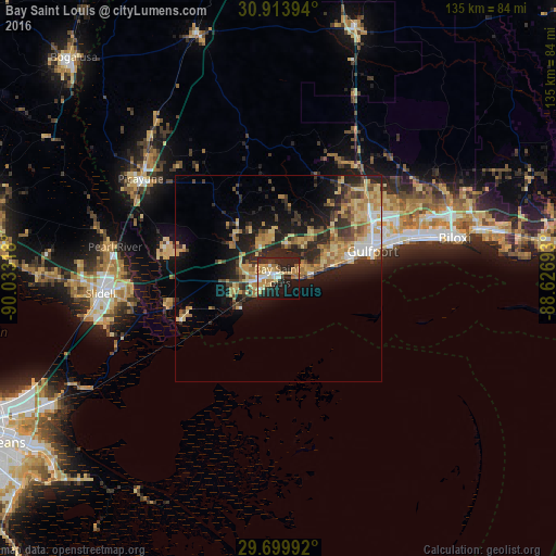
Analysis of Bay Saint Louis night lights 2016
Square area 10x10 km:
 4.76%
4.76%90-99
6.41%80-89
9.52%70-79
8.61%60-69
9.71%50-59
1.83%40-49
1.83%30-39
5.31%20-29
23.63%10-19
21.43%0-9
6.96%Square area 50x50 km:
1.36%90-99
1.44%80-89
3.77%70-79
3.21%60-69
3.33%50-59
1.59%40-49
2.11%30-39
3.14%20-29
6.48%10-19
8.86%0-9
64.71%Clear (daylight) street map image can be seen on geolist.org.
Map coordinates:
30° 54' 50.2" North, 90° 1' 59.4" West
30° 18' 31.7" North, 89° 19' 48.2" West
29° 41' 59.7" North, 88° 37' 36.9" West
Some cities around Bay Saint Louis sort by population:
• Gulfport
23.7 km =14.7 mi,  74°
74°
• West Gulfport
25 km =15.5 mi,  64°
64°
• Slidell
43.5 km =27 mi,  265°
265°
• Long Beach
17.6 km =10.9 mi, 74°
• Picayune
41.1 km =25.5 mi,  305°
305°
• Diamondhead
10.1 km =6.3 mi,  341°
341°
• Waveland
5.1 km =3.2 mi,  241°
241°
• Pass Christian
8 km =5 mi,  84°
84°
4417205 (p: 9,260)
Sources (retrieved 2019-11-25):
» Earth at Night: Flat Maps 2012, 2016