Lebanon night lights from space
Night Light of Lebanon (Oregon) from space (United States) Src. Average luminocity for 10x10km area is 17.2365% and for 50x50km: 3.5549%.
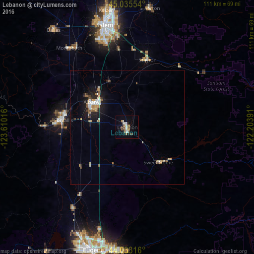
Analysis of Lebanon night lights 2016
Square area 10x10 km:
 2.86%
2.86%90-99
2.86%80-89
0.32%70-79
3.17%60-69
1.9%50-59
1.59%40-49
4.44%30-39
1.75%20-29
1.27%10-19
7.94%0-9
71.9%Square area 50x50 km:
0.44%90-99
0.64%80-89
0.3%70-79
0.43%60-69
0.5%50-59
0.41%40-49
0.46%30-39
0.28%20-29
0.71%10-19
2.8%0-9
93.02%Clear (daylight) street map image can be seen on geolist.org.
Map coordinates:
45° 2' 7.9" North, 123° 36' 36.6" West
44° 32' 11.4" North, 122° 54' 25.3" West
44° 1' 59.4" North, 122° 12' 14.1" West
Some cities around Lebanon sort by population:
• Corvallis
28.3 km =17.6 mi,  276°
276°
• Albany
19.3 km =12 mi,  305°
305°
• Four Corners
43.9 km =27.3 mi,  352°
352°
• Monmouth
43.3 km =26.9 mi,  323°
323°
• Sweet Home
20.5 km =12.7 mi,  138°
138°
• Independence
41.4 km =25.7 mi,  327°
327°
• Stayton
30.7 km =19.1 mi,  16°
16°
• Junction City
42.5 km =26.4 mi,  213°
213°
5736218 (p: 16,324)
Sources (retrieved 2019-11-25):
» Earth at Night: Flat Maps 2012, 2016