Laurel night lights from space
Night Light of Laurel (Virginia) from space (United States) Src. Average luminocity for 10x10km area is 83.0153% and for 50x50km: 36.6727%.
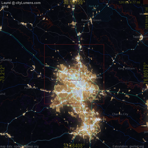
Analysis of Laurel night lights 2016
Square area 10x10 km:
 22.62%
90-99
21.26%80-89
14.12%70-79
17.52%60-69
14.12%50-59
8.67%40-49
1.02%30-39
0.68%20-29
0%10-19
0%0-9
0%Square area 50x50 km:
6.61%90-99
6.34%80-89
4.89%70-79
7%60-69
8.12%50-59
6.55%40-49
3.65%30-39
3.71%20-29
4.62%10-19
8.02%0-9
40.48%Clear (daylight) street map image can be seen on geolist.org.
Map coordinates:
38° 11' 51.3" North, 78° 12' 43.2" West
37° 38' 34.5" North, 77° 30' 31.9" West
37° 5' 2.7" North, 76° 48' 20.7" West
Some cities around Laurel sort by population:
• Richmond
10.8 km =6.7 mi,  156°
156°
• Tuckahoe
7.2 km =4.5 mi,  215°
215°
• Short Pump
9.2 km =5.7 mi,  275°
275°
• Glen Allen
2.6 km =1.6 mi,  4°
4°
• Lakeside
4.8 km =3 mi,  144°
144°
• Wyndham
11 km =6.8 mi,  304°
304°
• Dumbarton
4.6 km =2.9 mi, 160°
• Chamberlayne
7.3 km =4.5 mi,  104°
104°
4768678 (p: 16,713)
Sources (retrieved 2019-11-25):
» Earth at Night: Flat Maps 2012, 2016