Lancaster night lights from space
Night Light of Lancaster (South Carolina) from space (United States) Src. Average luminocity for 10x10km area is 57.5714% and for 50x50km: 14.3493%.
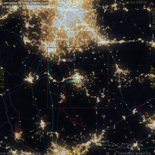
Analysis of Lancaster night lights 2016
Square area 10x10 km:
 7.14%
7.14%90-99
8.97%80-89
13.37%70-79
11.17%60-69
12.64%50-59
4.58%40-49
8.97%30-39
5.49%20-29
19.6%10-19
7.88%0-9
0.18%Square area 50x50 km:
0.97%90-99
0.99%80-89
2.17%70-79
2.22%60-69
2.55%50-59
2.05%40-49
2.69%30-39
3.59%20-29
4.39%10-19
8.55%0-9
69.83%Clear (daylight) street map image can be seen on geolist.org.
Map coordinates:
35° 17' 46.8" North, 81° 28' 26.5" West
34° 43' 13.5" North, 80° 46' 15.2" West
34° 8' 25.8" North, 80° 4' 4" West
Some cities around Lancaster sort by population:
• Rock Hill
32.5 km =20.2 mi,  314°
314°
• Monroe
35.7 km =22.2 mi,  34°
34°
• Fort Mill
35.6 km =22.1 mi,  333°
333°
• Waxhaw
22.8 km =14.2 mi,  6°
6°
• Weddington
33.6 km =20.9 mi,  1°
1°
• Wesley Chapel
33.1 km =20.6 mi,  15°
15°
• Marvin
30.4 km =18.9 mi,  352°
352°
• Chester
40.6 km =25.2 mi,  267°
267°
4584556 (p: 8,956)
Sources (retrieved 2019-11-25):
» Earth at Night: Flat Maps 2012, 2016