James City night lights from space
Night Light of James City (North Carolina) from space (United States) Src. Average luminocity for 10x10km area is 48.6276% and for 50x50km: 8.7292%.
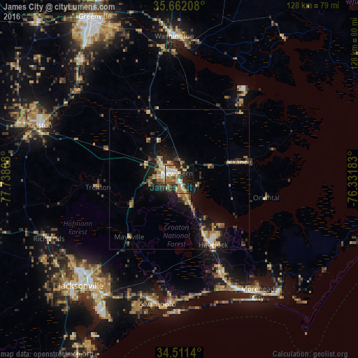
Analysis of James City night lights 2016
Square area 10x10 km:
 6.12%
6.12%90-99
7.34%80-89
9.27%70-79
7.87%60-69
12.41%50-59
3.67%40-49
5.59%30-39
4.9%20-29
18.01%10-19
20.28%0-9
4.55%Square area 50x50 km:
0.67%90-99
0.74%80-89
1.35%70-79
1.49%60-69
2%50-59
0.91%40-49
0.97%30-39
1.3%20-29
2.96%10-19
6.15%0-9
81.45%Clear (daylight) street map image can be seen on geolist.org.
Map coordinates:
35° 39' 43.5" North, 77° 44' 17.1" West
35° 5' 19.6" North, 77° 2' 5.8" West
34° 30' 41" North, 76° 19' 54.6" West
Some cities around James City sort by population:
• Jacksonville
51.8 km =32.2 mi,  224°
224°
• New Bern
2.3 km =1.4 mi,  339°
339°
• Kinston
53.3 km =33.1 mi,  291°
291°
• Havelock
26.3 km =16.3 mi,  152°
152°
• Piney Green
48.9 km =30.4 mi,  212°
212°
• Washington
50.9 km =31.6 mi,  358°
358°
• Morehead City
49.5 km =30.8 mi, 145°
• Half Moon
48.5 km =30.1 mi,  232°
232°
4473137 (p: 5,899)
Sources (retrieved 2019-11-25):
» Earth at Night: Flat Maps 2012, 2016