Hurricane night lights from space
Night Light of Hurricane (West Virginia) from space (United States) Src. Average luminocity for 10x10km area is 28.1834% and for 50x50km: 11.8157%.
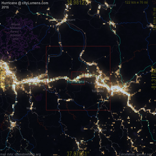
Analysis of Hurricane night lights 2016
Square area 10x10 km:
 1.95%
1.95%90-99
3.73%80-89
3.08%70-79
2.92%60-69
6.98%50-59
5.19%40-49
2.6%30-39
4.71%20-29
2.27%10-19
42.53%0-9
24.03%Square area 50x50 km:
1.12%90-99
1.68%80-89
1.23%70-79
1.28%60-69
1.59%50-59
2.31%40-49
2.01%30-39
2.22%20-29
3.43%10-19
9.13%0-9
74%Clear (daylight) street map image can be seen on geolist.org.
Map coordinates:
38° 58' 52.6" North, 82° 43' 23.8" West
38° 25' 57.3" North, 82° 1' 12.5" West
37° 52' 47" North, 81° 19' 1.3" West
Some cities around Hurricane sort by population:
• Charleston
35 km =21.7 mi,  105°
105°
• Teays Valley
8.1 km =5 mi,  76°
76°
• South Charleston
28.8 km =17.9 mi,  104°
104°
• Saint Albans
16.9 km =10.5 mi, 108°
• Cross Lanes
20 km =12.4 mi,  93°
93°
• Dunbar
25.9 km =16.1 mi, 107°
• Nitro
15.5 km =9.6 mi, 97°
• Pea Ridge
26.2 km =16.3 mi,  265°
265°
4809558 (p: 6,493)
Sources (retrieved 2019-11-25):
» Earth at Night: Flat Maps 2012, 2016