Cross Lanes night lights from space
Night Light of Cross Lanes (West Virginia) from space (United States) Src. Average luminocity for 10x10km area is 61.4838% and for 50x50km: 16.9767%.
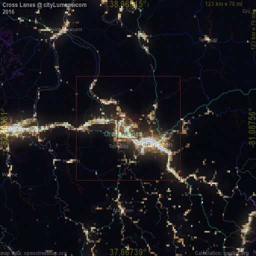
Analysis of Cross Lanes night lights 2016
Square area 10x10 km:
 13.15%
90-99
12.34%80-89
6.33%70-79
6.17%60-69
8.93%50-59
15.58%40-49
12.66%30-39
10.23%20-29
7.47%10-19
6.66%0-9
0.49%Square area 50x50 km:
2.15%90-99
2.59%80-89
1.58%70-79
1.75%60-69
2.37%50-59
3.37%40-49
2.7%30-39
2.95%20-29
5.76%10-19
12.41%0-9
62.37%Clear (daylight) street map image can be seen on geolist.org.
Map coordinates:
38° 58' 8.9" North, 82° 29' 37.7" West
38° 25' 13.3" North, 81° 47' 26.4" West
37° 52' 2.6" North, 81° 5' 15.2" West
Some cities around Cross Lanes sort by population:
• Charleston
15.9 km =9.9 mi,  119°
119°
• Teays Valley
12.5 km =7.8 mi,  285°
285°
• South Charleston
9.8 km =6.1 mi,  126°
126°
• Saint Albans
5.5 km =3.4 mi,  225°
225°
• Dunbar
8.1 km =5 mi,  145°
145°
• Nitro
4.7 km =2.9 mi,  262°
262°
• Pea Ridge
46.1 km =28.6 mi,  269°
269°
• Hurricane
20 km =12.4 mi, 273°
4803372 (p: 9,995)
Sources (retrieved 2019-11-25):
» Earth at Night: Flat Maps 2012, 2016