Haslett night lights from space
Night Light of Haslett (Michigan) from space (United States) Src. Average luminocity for 10x10km area is 39.3606% and for 50x50km: 15.7294%.
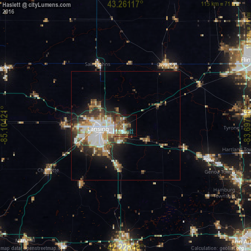
Analysis of Haslett night lights 2016
Square area 10x10 km:
 4.09%
4.09%90-99
6.21%80-89
3.79%70-79
3.48%60-69
7.42%50-59
14.7%40-49
10.61%30-39
4.09%20-29
5.45%10-19
14.85%0-9
25.3%Square area 50x50 km:
3.4%90-99
3.25%80-89
1.31%70-79
1.43%60-69
2.05%50-59
2.53%40-49
2.45%30-39
2.28%20-29
3.25%10-19
6.09%0-9
71.97%Clear (daylight) street map image can be seen on geolist.org.
Map coordinates:
43° 15' 40.2" North, 85° 6' 15.2" West
42° 44' 49.1" North, 84° 24' 3.9" West
42° 13' 42.5" North, 83° 41' 52.7" West
Some cities around Haslett sort by population:
• Lansing
12.7 km =7.9 mi,  262°
262°
• East Lansing
6.9 km =4.3 mi, 260°
• Holt
15.1 km =9.4 mi,  218°
218°
• Waverly
18 km =11.2 mi,  267°
267°
• Okemos
3.5 km =2.2 mi, 218°
• Mason
19 km =11.8 mi,  190°
190°
• Saint Johns
31.1 km =19.3 mi,  335°
335°
• Grand Ledge
28.2 km =17.5 mi, 271°
4995514 (p: 19,220)
Sources (retrieved 2019-11-25):
» Earth at Night: Flat Maps 2012, 2016