Hammonton night lights from space
Night Light of Hammonton (New Jersey) from space (United States) Src. Average luminocity for 10x10km area is 34.0422% and for 50x50km: 25.8505%.
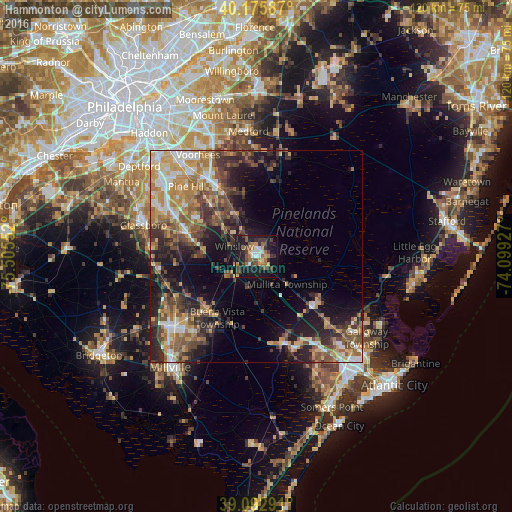
Analysis of Hammonton night lights 2016
Square area 10x10 km:
 3.08%
3.08%90-99
3.25%80-89
1.62%70-79
6.01%60-69
6.82%50-59
6.17%40-49
6.01%30-39
8.28%20-29
9.58%10-19
39.77%0-9
9.42%Square area 50x50 km:
2.76%90-99
3.43%80-89
3.31%70-79
4.54%60-69
4.76%50-59
4.51%40-49
4.99%30-39
4.95%20-29
6.63%10-19
11.94%0-9
48.18%Clear (daylight) street map image can be seen on geolist.org.
Map coordinates:
40° 10' 33.1" North, 75° 30' 19.9" West
39° 38' 11.4" North, 74° 48' 8.6" West
39° 5' 34.5" North, 74° 5' 57.4" West
Some cities around Hammonton sort by population:
• Vineland
25.4 km =15.8 mi,  228°
228°
• Jackson
16.4 km =10.2 mi,  341°
341°
• Sicklerville
16.9 km =10.5 mi,  302°
302°
• Williamstown
17.4 km =10.8 mi,  288°
288°
• Atco
16.5 km =10.3 mi,  333°
333°
• Pine Hill
23.1 km =14.4 mi,  315°
315°
• Clayton
24.9 km =15.5 mi,  276°
276°
• Berlin
20.3 km =12.6 mi, 327°
4502129 (p: 14,618)
Sources (retrieved 2019-11-25):
» Earth at Night: Flat Maps 2012, 2016