Guthrie night lights from space
Night Light of Guthrie (Oklahoma) from space (United States) Src. Average luminocity for 10x10km area is 29.4469% and for 50x50km: 9.5587%.
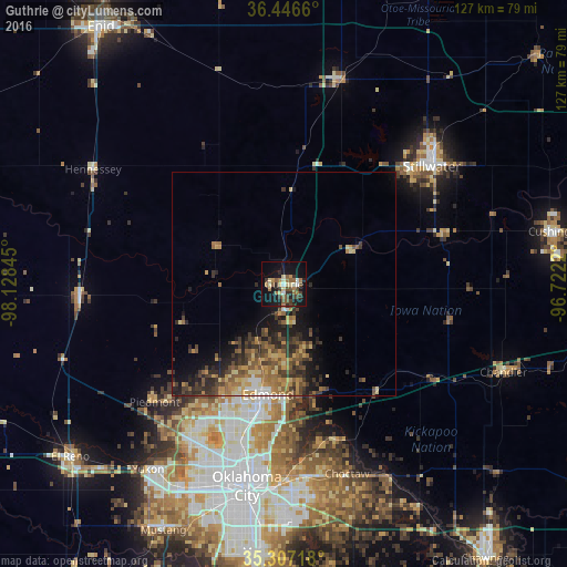
Analysis of Guthrie night lights 2016
Square area 10x10 km:
 1.83%
1.83%90-99
3.3%80-89
5.13%70-79
1.47%60-69
7.14%50-59
5.86%40-49
5.49%30-39
6.59%20-29
3.3%10-19
30.22%0-9
29.67%Square area 50x50 km:
0.36%90-99
0.48%80-89
1.44%70-79
1.67%60-69
2.08%50-59
2.15%40-49
1.95%30-39
2.66%20-29
2.76%10-19
5.29%0-9
79.15%Clear (daylight) street map image can be seen on geolist.org.
Map coordinates:
36° 26' 47.8" North, 98° 7' 42.4" West
35° 52' 44.2" North, 97° 25' 31.2" West
35° 18' 25.8" North, 96° 43' 19.9" West
Some cities around Guthrie sort by population:
• Oklahoma City
46.5 km =28.9 mi,  190°
190°
• Edmond
25.6 km =15.9 mi, 190°
• Stillwater
42.2 km =26.2 mi,  51°
51°
• Bethany
44.2 km =27.5 mi,  205°
205°
• Choctaw
44.7 km =27.8 mi,  161°
161°
• Warr Acres
43.3 km =26.9 mi,  203°
203°
• The Village
37.2 km =23.1 mi, 197°
• Piedmont
39.2 km =24.4 mi,  227°
227°
4538142 (p: 11,270)
Sources (retrieved 2019-11-25):
» Earth at Night: Flat Maps 2012, 2016