Green Haven night lights from space
Night Light of Green Haven (Maryland) from space (United States) Src. Average luminocity for 10x10km area is 73.2484% and for 50x50km: 54.6416%.
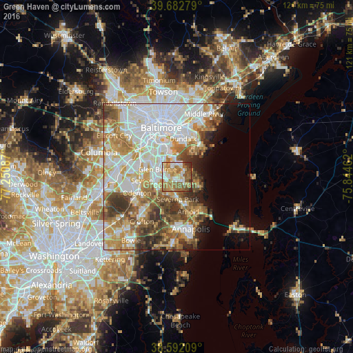
Analysis of Green Haven night lights 2016
Square area 10x10 km:
 11.53%
90-99
15.75%80-89
12.18%70-79
12.18%60-69
23.7%50-59
15.42%40-49
4.06%30-39
3.25%20-29
1.95%10-19
0%0-9
0%Square area 50x50 km:
16.74%90-99
12.41%80-89
6.32%70-79
8.08%60-69
7.08%50-59
7%40-49
5.58%30-39
5.28%20-29
3.39%10-19
4.32%0-9
23.81%Clear (daylight) street map image can be seen on geolist.org.
Map coordinates:
39° 40' 58" North, 77° 15' 3.1" West
39° 8' 22.4" North, 76° 32' 51.9" West
38° 35' 31.5" North, 75° 50' 40.6" West
Some cities around Green Haven sort by population:
• Glen Burnie
7.1 km =4.4 mi,  291°
291°
• Severna Park
7.7 km =4.8 mi,  178°
178°
• South Gate
6.8 km =4.2 mi,  260°
260°
• Pasadena
4.1 km =2.5 mi,  209°
209°
• Lake Shore
6.5 km =4 mi,  123°
123°
• Ferndale
9.3 km =5.8 mi,  301°
301°
• Brooklyn Park
11.5 km =7.1 mi,  329°
329°
• Riviera Beach
4.6 km =2.9 mi,  48°
48°
4356783 (p: 19,326)
Sources (retrieved 2019-11-25):
» Earth at Night: Flat Maps 2012, 2016