Grafton night lights from space
Night Light of Grafton (Ohio) from space (United States) Src. Average luminocity for 10x10km area is 21.7354% and for 50x50km: 37.0006%.
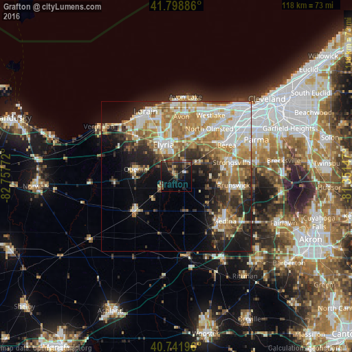
Analysis of Grafton night lights 2016
Square area 10x10 km:
 0.65%
0.65%90-99
1.62%80-89
0.97%70-79
0.65%60-69
3.25%50-59
4.55%40-49
7.79%30-39
4.87%20-29
15.1%10-19
20.94%0-9
39.61%Square area 50x50 km:
7.45%90-99
7.56%80-89
4.89%70-79
4.82%60-69
7.64%50-59
4.55%40-49
3.66%30-39
4.33%20-29
7.03%10-19
10.47%0-9
37.6%Clear (daylight) street map image can be seen on geolist.org.
Map coordinates:
41° 47' 55.9" North, 82° 45' 27.8" West
41° 16' 21.2" North, 82° 3' 16.5" West
40° 44' 31.1" North, 81° 21' 5.3" West
Some cities around Grafton sort by population:
• Elyria
11.5 km =7.1 mi,  337°
337°
• Strongsville
18.9 km =11.7 mi,  75°
75°
• Brunswick
18.2 km =11.3 mi,  102°
102°
• North Ridgeville
13.3 km =8.3 mi,  12°
12°
• North Olmsted
19.3 km =12 mi,  34°
34°
• Berea
19.7 km =12.2 mi,  58°
58°
• Olmsted Falls
16.7 km =10.4 mi,  47°
47°
• Oberlin
13.8 km =8.6 mi,  279°
279°
5156170 (p: 6,165)
Sources (retrieved 2019-11-25):
» Earth at Night: Flat Maps 2012, 2016