Geneseo night lights from space
Night Light of Geneseo (Illinois) from space (United States) Src. Average luminocity for 10x10km area is 13.3282% and for 50x50km: 6.815%.
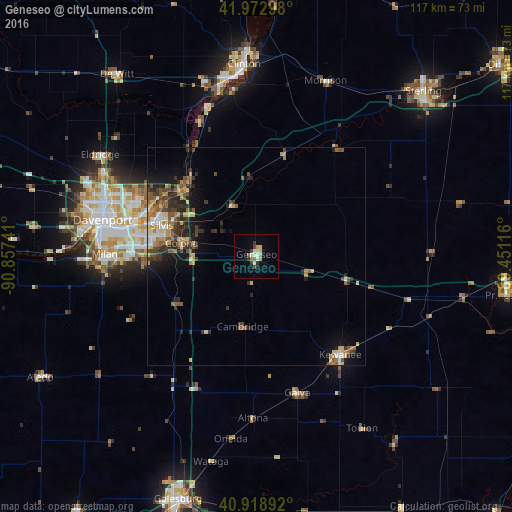
Analysis of Geneseo night lights 2016
Square area 10x10 km:
 0.68%
0.68%90-99
2.89%80-89
2.55%70-79
2.04%60-69
1.53%50-59
0.51%40-49
1.02%30-39
2.89%20-29
0.85%10-19
1.7%0-9
83.33%Square area 50x50 km:
0.45%90-99
0.71%80-89
1.16%70-79
0.88%60-69
1.01%50-59
1.38%40-49
1.08%30-39
1.59%20-29
2.11%10-19
3.1%0-9
86.52%Clear (daylight) street map image can be seen on geolist.org.
Map coordinates:
41° 58' 22.7" North, 90° 51' 26.7" West
41° 26' 53.1" North, 90° 9' 15.4" West
40° 55' 8.1" North, 89° 27' 4.2" West
Some cities around Geneseo sort by population:
• Moline
30.8 km =19.1 mi,  282°
282°
• Rock Island
36 km =22.4 mi, 280°
• Bettendorf
31.3 km =19.4 mi,  285°
285°
• East Moline
24.9 km =15.5 mi, 283°
• Kewanee
29.6 km =18.4 mi,  139°
139°
• Silvis
22.9 km =14.2 mi, 288°
• Colona
17 km =10.6 mi, 283°
• Milan
34.8 km =21.6 mi,  270°
270°
4893581 (p: 6,538)
Sources (retrieved 2019-11-25):
» Earth at Night: Flat Maps 2012, 2016