Franklin night lights from space
Night Light of Franklin (Virginia) from space (United States) Src. Average luminocity for 10x10km area is 30.456% and for 50x50km: 3.5335%.
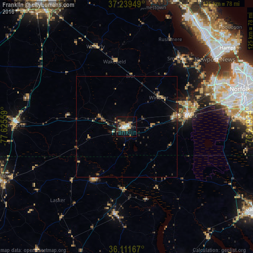
Analysis of Franklin night lights 2016
Square area 10x10 km:
 4.76%
4.76%90-99
4.03%80-89
2.93%70-79
7.88%60-69
2.56%50-59
4.95%40-49
0%30-39
3.66%20-29
4.95%10-19
38.1%0-9
26.19%Square area 50x50 km:
0.21%90-99
0.23%80-89
0.41%70-79
0.75%60-69
0.33%50-59
0.61%40-49
0.27%30-39
1.12%20-29
0.7%10-19
2.54%0-9
92.85%Clear (daylight) street map image can be seen on geolist.org.
Map coordinates:
37° 14' 22.2" North, 77° 37' 32.1" West
36° 40' 39.5" North, 76° 55' 20.9" West
36° 6' 42" North, 76° 13' 9.6" West
Some cities around Franklin sort by population:
• Norfolk
59.8 km =37.2 mi,  71°
71°
• Chesapeake
59.8 km =37.2 mi, 74°
• Portsmouth Heights
51.8 km =32.2 mi, 72°
• Portsmouth
58.3 km =36.2 mi, 72°
• Suffolk
30.6 km =19 mi,  79°
79°
• South Suffolk
29.9 km =18.6 mi, 81°
• Smithfield
42.7 km =26.5 mi,  37°
37°
• Emporia
55.3 km =34.4 mi,  270°
270°
4759986 (p: 8,490)
Sources (retrieved 2019-11-25):
» Earth at Night: Flat Maps 2012, 2016