Fort Knox night lights from space
Night Light of Fort Knox (Kentucky) from space (United States) Src. Average luminocity for 10x10km area is 43.0049% and for 50x50km: 14.3047%.
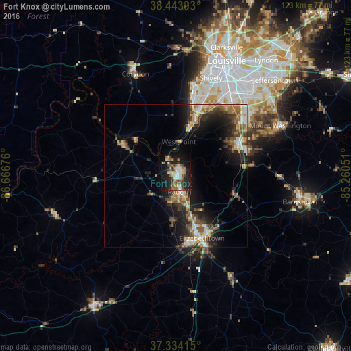
Analysis of Fort Knox night lights 2016
Square area 10x10 km:
 6.98%
6.98%90-99
7.95%80-89
4.87%70-79
2.92%60-69
8.28%50-59
8.6%40-49
3.08%30-39
5.03%20-29
18.18%10-19
30.68%0-9
3.41%Square area 50x50 km:
1.38%90-99
2.02%80-89
1.97%70-79
1.93%60-69
2.34%50-59
2.4%40-49
2.18%30-39
2.59%20-29
4.66%10-19
8.69%0-9
69.84%Clear (daylight) street map image can be seen on geolist.org.
Map coordinates:
38° 26' 38.1" North, 86° 40' 0.3" West
37° 53' 28.1" North, 85° 57' 49.1" West
37° 20' 2.9" North, 85° 15' 37.8" West
Some cities around Fort Knox sort by population:
• Elizabethtown
23.8 km =14.8 mi,  157°
157°
• Pleasure Ridge Park
29.7 km =18.5 mi,  18°
18°
• Valley Station
25.8 km =16 mi, 18°
• Radcliff
5.8 km =3.6 mi,  167°
167°
• Shepherdsville
24.3 km =15.1 mi,  63°
63°
• Fairdale
29.8 km =18.5 mi,  37°
37°
• Hillview
31.4 km =19.5 mi,  50°
50°
• Vine Grove
9.1 km =5.7 mi,  189°
189°
7259771 (p: 10,124)
Sources (retrieved 2019-11-25):
» Earth at Night: Flat Maps 2012, 2016