Edgemere night lights from space
Night Light of Edgemere (Maryland) from space (United States) Src. Average luminocity for 10x10km area is 50.0391% and for 50x50km: 47.0353%.
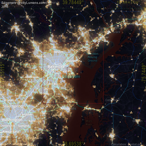
Analysis of Edgemere night lights 2016
Square area 10x10 km:
 6.29%
6.29%90-99
7.31%80-89
9.01%70-79
7.65%60-69
10.03%50-59
9.52%40-49
6.8%30-39
9.18%20-29
12.41%10-19
13.1%0-9
8.67%Square area 50x50 km:
15.57%90-99
10.87%80-89
5.26%70-79
5.76%60-69
5.93%50-59
5.69%40-49
4.61%30-39
3.85%20-29
3.98%10-19
4.21%0-9
34.27%Clear (daylight) street map image can be seen on geolist.org.
Map coordinates:
39° 47' 4.2" North, 77° 9' 4.1" West
39° 14' 31.4" North, 76° 26' 52.9" West
38° 41' 43.4" North, 75° 44' 41.6" West
Some cities around Edgemere sort by population:
• Dundalk
6.3 km =3.9 mi,  278°
278°
• Essex
7.8 km =4.8 mi,  342°
342°
• Middle River
10.3 km =6.4 mi,  4°
4°
• Green Haven
14.3 km =8.9 mi,  217°
217°
• Rosedale
10.4 km =6.5 mi,  326°
326°
• Rossville
11.1 km =6.9 mi,  345°
345°
• Riviera Beach
9.8 km =6.1 mi,  211°
211°
• Bowleys Quarters
11.5 km =7.1 mi,  25°
25°
4354060 (p: 8,669)
Sources (retrieved 2019-11-25):
» Earth at Night: Flat Maps 2012, 2016