East Franklin night lights from space
Night Light of East Franklin (New Jersey) from space (United States) Src. Average luminocity for 10x10km area is 87.8861% and for 50x50km: 62.6919%.
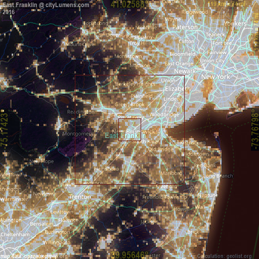
Analysis of East Franklin night lights 2016
Square area 10x10 km:
 31.8%
31.8%90-99
28.74%80-89
9.01%70-79
16.33%60-69
10.2%50-59
2.04%40-49
1.87%30-39
0%20-29
0%10-19
0%0-9
0%Square area 50x50 km:
13.76%90-99
12.71%80-89
8.08%70-79
9.66%60-69
11.62%50-59
12.48%40-49
8.15%30-39
6.9%20-29
6.02%10-19
4.69%0-9
5.94%Clear (daylight) street map image can be seen on geolist.org.
Map coordinates:
41° 1' 33.2" North, 75° 10' 27.2" West
40° 29' 35.9" North, 74° 28' 16" West
39° 57' 23.3" North, 73° 46' 4.7" West
Some cities around East Franklin sort by population:
• Edison
5.7 km =3.5 mi,  60°
60°
• New Brunswick
1.8 km =1.1 mi,  115°
115°
• Piscataway
6.1 km =3.8 mi,  83°
83°
• Voorhees
1.7 km =1.1 mi,  217°
217°
• Somerset
1.5 km =0.9 mi,  288°
288°
• Highland Park
4 km =2.5 mi,  85°
85°
• Franklin Park
8.1 km =5 mi, 221°
• Milltown
4.8 km =3 mi,  150°
150°
7315293 (p: 8,669)
Sources (retrieved 2019-11-25):
» Earth at Night: Flat Maps 2012, 2016