Dickson night lights from space
Night Light of Dickson (Tennessee) from space (United States) Src. Average luminocity for 10x10km area is 47.4322% and for 50x50km: 5.587%.
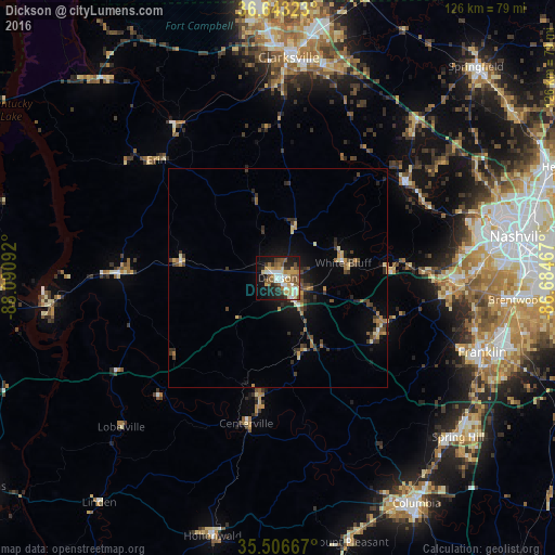
Analysis of Dickson night lights 2016
Square area 10x10 km:
 6.41%
6.41%90-99
8.24%80-89
9.16%70-79
7.33%60-69
6.04%50-59
11.72%40-49
4.03%30-39
4.95%20-29
9.16%10-19
23.99%0-9
8.97%Square area 50x50 km:
0.29%90-99
0.45%80-89
0.92%70-79
0.73%60-69
0.78%50-59
0.97%40-49
0.79%30-39
1.5%20-29
1.23%10-19
3.42%0-9
88.93%Clear (daylight) street map image can be seen on geolist.org.
Map coordinates:
36° 38' 35.6" North, 88° 5' 27.3" West
36° 4' 37.2" North, 87° 23' 16" West
35° 30' 24" North, 86° 41' 4.8" West
Some cities around Dickson sort by population:
• Nashville
55.1 km =34.2 mi,  79°
79°
• Clarksville
50.4 km =31.3 mi,  2°
2°
• Franklin
49.6 km =30.8 mi,  109°
109°
• Brentwood
54.6 km =33.9 mi,  95°
95°
• Spring Hill
54.9 km =34.1 mi,  131°
131°
• Brentwood Estates
55 km =34.2 mi, 96°
• Fairview
26.2 km =16.3 mi, 113°
• Forest Hills
48.9 km =30.4 mi,  91°
91°
4618057 (p: 15,359)
Sources (retrieved 2019-11-25):
» Earth at Night: Flat Maps 2012, 2016