Inwood night lights from space
Night Light of Inwood (Florida) from space (United States) Src. Average luminocity for 10x10km area is 77.1629% and for 50x50km: 42.3301%.
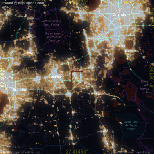
Analysis of Inwood night lights 2016
Square area 10x10 km:
 14.58%
90-99
18.75%80-89
9.47%70-79
13.26%60-69
31.63%50-59
7.95%40-49
3.41%30-39
0.95%20-29
0%10-19
0%0-9
0%Square area 50x50 km:
4.74%90-99
5.82%80-89
3.25%70-79
4.89%60-69
15.89%50-59
7.6%40-49
7.83%30-39
7.68%20-29
9.74%10-19
14.06%0-9
18.49%Clear (daylight) street map image can be seen on geolist.org.
Map coordinates:
28° 39' 20.8" North, 82° 28' 5.6" West
28° 2' 13.1" North, 81° 45' 54.3" West
27° 24' 52.5" North, 81° 3' 43.1" West
Some cities around Inwood sort by population:
• Winter Haven
3.6 km =2.2 mi,  117°
117°
• Auburndale
3.9 km =2.4 mi,  323°
323°
• Highland City
13.6 km =8.5 mi,  234°
234°
• Cypress Gardens
8.8 km =5.5 mi, 123°
• Jan-Phyl Village
2.6 km =1.6 mi,  194°
194°
• Fussels Corner
9.6 km =6 mi,  281°
281°
• Lake Alfred
7.4 km =4.6 mi,  33°
33°
• Wahneta
10.1 km =6.3 mi,  158°
158°
4159796 (p: 6,403)
Sources (retrieved 2019-11-25):
» Earth at Night: Flat Maps 2012, 2016