Cheney night lights from space
Night Light of Cheney (Washington) from space (United States) Src. Average luminocity for 10x10km area is 10.2429% and for 50x50km: 9.7594%.
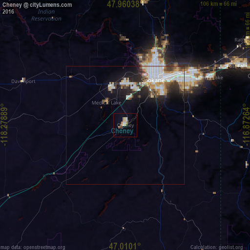
Analysis of Cheney night lights 2016
Square area 10x10 km:
 1.42%
1.42%90-99
1.7%80-89
0.99%70-79
2.41%60-69
1.14%50-59
0.28%40-49
0.57%30-39
1.99%20-29
0.28%10-19
0.71%0-9
88.49%Square area 50x50 km:
2.58%90-99
2.09%80-89
0.95%70-79
1.19%60-69
0.65%50-59
0.97%40-49
0.86%30-39
1.48%20-29
2.19%10-19
4.29%0-9
82.74%Clear (daylight) street map image can be seen on geolist.org.
Map coordinates:
47° 57' 37.4" North, 118° 16' 44" West
47° 29' 14.6" North, 117° 34' 32.7" West
47° 0' 36.4" North, 116° 52' 21.5" West
Some cities around Cheney sort by population:
• Spokane
22.1 km =13.7 mi,  29°
29°
• Spokane Valley
32.6 km =20.3 mi,  50°
50°
• Opportunity
31 km =19.3 mi, 54°
• Veradale
33 km =20.5 mi,  56°
56°
• Dishman
29.6 km =18.4 mi, 49°
• Fairwood
33.3 km =20.7 mi,  20°
20°
• Airway Heights
17.5 km =10.9 mi,  355°
355°
• Country Homes
31.7 km =19.7 mi, 23°
5789856 (p: 11,534)
Sources (retrieved 2019-11-25):
» Earth at Night: Flat Maps 2012, 2016