Calhoun night lights from space
Night Light of Calhoun (Georgia) from space (United States) Src. Average luminocity for 10x10km area is 53.722% and for 50x50km: 11.4223%.
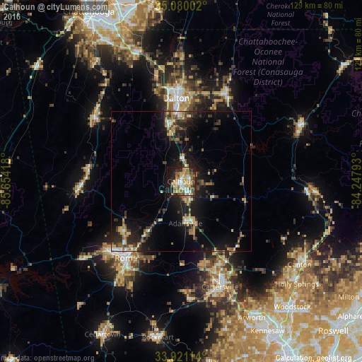
Analysis of Calhoun night lights 2016
Square area 10x10 km:
 7.52%
7.52%90-99
7.69%80-89
10.66%70-79
11.89%60-69
8.92%50-59
9.09%40-49
5.94%30-39
6.47%20-29
10.84%10-19
19.06%0-9
1.92%Square area 50x50 km:
0.91%90-99
0.9%80-89
1.76%70-79
1.63%60-69
1.56%50-59
1.64%40-49
1.56%30-39
2.67%20-29
3.78%10-19
10.1%0-9
73.48%Clear (daylight) street map image can be seen on geolist.org.
Map coordinates:
35° 4' 48.1" North, 85° 39' 15" West
34° 30' 9.3" North, 84° 57' 3.8" West
33° 55' 16.1" North, 84° 14' 52.5" West
Some cities around Calhoun sort by population:
• Rome
33.6 km =20.9 mi,  215°
215°
• Dalton
29.8 km =18.5 mi,  356°
356°
• Canton
51.6 km =32.1 mi,  124°
124°
• Acworth
54.6 km =33.9 mi,  152°
152°
• Cartersville
39.9 km =24.8 mi,  159°
159°
• Holly Springs
55.1 km =34.2 mi,  131°
131°
• Fort Oglethorpe
57 km =35.4 mi,  330°
330°
• LaFayette
37.7 km =23.4 mi,  306°
306°
4185657 (p: 16,309)
Sources (retrieved 2019-11-25):
» Earth at Night: Flat Maps 2012, 2016