Brooklyn night lights from space
Night Light of Brooklyn (Ohio) from space (United States) Src. Average luminocity for 10x10km area is 99.3248% and for 50x50km: 54.8546%.
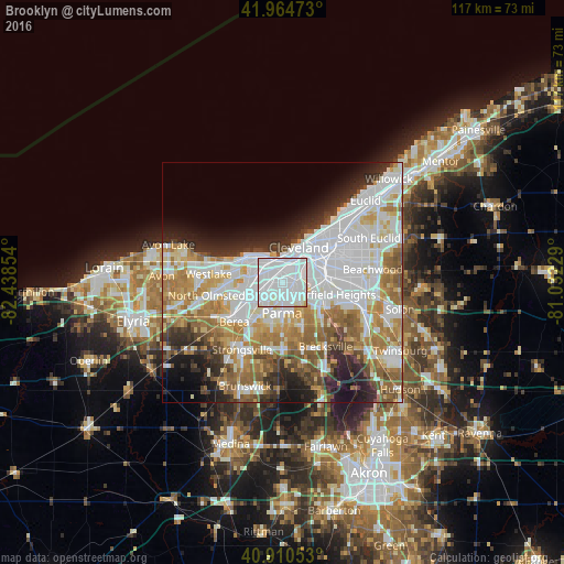
Analysis of Brooklyn night lights 2016
Square area 10x10 km:
 75%
75%90-99
24.15%80-89
0.85%70-79
0%60-69
0%50-59
0%40-49
0%30-39
0%20-29
0%10-19
0%0-9
0%Square area 50x50 km:
18.76%90-99
12.77%80-89
4.95%70-79
6.02%60-69
8.95%50-59
5.89%40-49
3.95%30-39
4.17%20-29
6.69%10-19
6.88%0-9
20.97%Clear (daylight) street map image can be seen on geolist.org.
Map coordinates:
41° 57' 53" North, 82° 26' 18.7" West
41° 26' 23.2" North, 81° 44' 7.5" West
40° 54' 37.9" North, 81° 1' 56.2" West
Some cities around Brooklyn sort by population:
• Cleveland
7.4 km =4.6 mi,  26°
26°
• Parma
4 km =2.5 mi,  165°
165°
• Lakewood
7 km =4.3 mi,  311°
311°
• Rocky River
9.5 km =5.9 mi,  294°
294°
• Parma Heights
5.9 km =3.7 mi,  200°
200°
• Clark-Fulton
3.4 km =2.1 mi,  38°
38°
• Detroit-Shoreway
4.2 km =2.6 mi,  6°
6°
• Seven Hills
7 km =4.3 mi,  135°
135°
5148346 (p: 10,899)
Sources (retrieved 2019-11-25):
» Earth at Night: Flat Maps 2012, 2016