Battle Ground night lights from space
Night Light of Battle Ground (Washington) from space (United States) Src. Average luminocity for 10x10km area is 23.4556% and for 50x50km: 19.2441%.
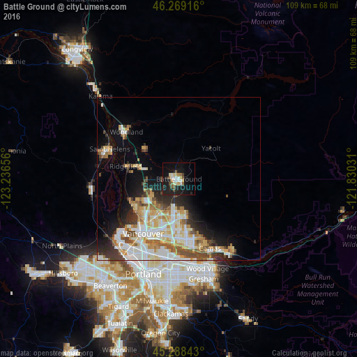
Analysis of Battle Ground night lights 2016
Square area 10x10 km:
 3.02%
3.02%90-99
4.13%80-89
3.49%70-79
1.43%60-69
1.9%50-59
3.81%40-49
1.9%30-39
1.27%20-29
6.51%10-19
30.79%0-9
41.75%Square area 50x50 km:
3.98%90-99
4.59%80-89
2.43%70-79
2.66%60-69
2.2%50-59
2.12%40-49
2.18%30-39
1.89%20-29
3.62%10-19
6.37%0-9
67.95%Clear (daylight) street map image can be seen on geolist.org.
Map coordinates:
46° 16' 9" North, 123° 14' 11.6" West
45° 46' 51.4" North, 122° 32' 0.3" West
45° 17' 18.3" North, 121° 49' 49.1" West
Some cities around Battle Ground sort by population:
• Salmon Creek
11.9 km =7.4 mi,  228°
228°
• Orchards
12.9 km =8 mi,  189°
189°
• Five Corners
11.2 km =7 mi,  196°
196°
• Walnut Grove
13.6 km =8.5 mi, 202°
• Mill Plain
15.7 km =9.8 mi,  168°
168°
• Mount Vista
9.3 km =5.8 mi,  236°
236°
• Felida
15.7 km =9.8 mi, 239°
• Barberton
11 km =6.8 mi,  207°
207°
5786485 (p: 19,407)
Sources (retrieved 2019-11-25):
» Earth at Night: Flat Maps 2012, 2016