Mount Vista night lights from space
Night Light of Mount Vista (Washington) from space (United States) Src. Average luminocity for 10x10km area is 45.5803% and for 50x50km: 29.8363%.
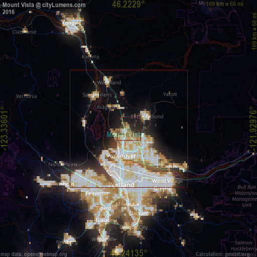
Analysis of Mount Vista night lights 2016
Square area 10x10 km:
 4.24%
4.24%90-99
4.24%80-89
6.06%70-79
11.06%60-69
9.39%50-59
5.91%40-49
10.3%30-39
6.82%20-29
16.67%10-19
25%0-9
0.3%Square area 50x50 km:
8.1%90-99
8.44%80-89
3.67%70-79
3.27%60-69
2.72%50-59
2.48%40-49
2.56%30-39
2.25%20-29
4.43%10-19
7.4%0-9
54.69%Clear (daylight) street map image can be seen on geolist.org.
Map coordinates:
46° 13' 22.4" North, 123° 20' 9.6" West
45° 44' 3.4" North, 122° 37' 58.4" West
45° 14' 28.9" North, 121° 55' 47.1" West
Some cities around Mount Vista sort by population:
• Salmon Creek
2.9 km =1.8 mi,  205°
205°
• Hazel Dell
7.4 km =4.6 mi,  198°
198°
• Five Corners
7.1 km =4.4 mi,  140°
140°
• Walnut Grove
7.8 km =4.8 mi,  160°
160°
• Minnehaha
8.5 km =5.3 mi,  188°
188°
• Felida
6.4 km =4 mi,  244°
244°
• Lake Shore
6.6 km =4.1 mi,  222°
222°
• Barberton
5.3 km =3.3 mi,  150°
150°
5804135 (p: 7,850)
Sources (retrieved 2019-11-25):
» Earth at Night: Flat Maps 2012, 2016