Abbeville night lights from space
Night Light of Abbeville (South Carolina) from space (United States) Src. Average luminocity for 10x10km area is 34.0952% and for 50x50km: 7.9861%.
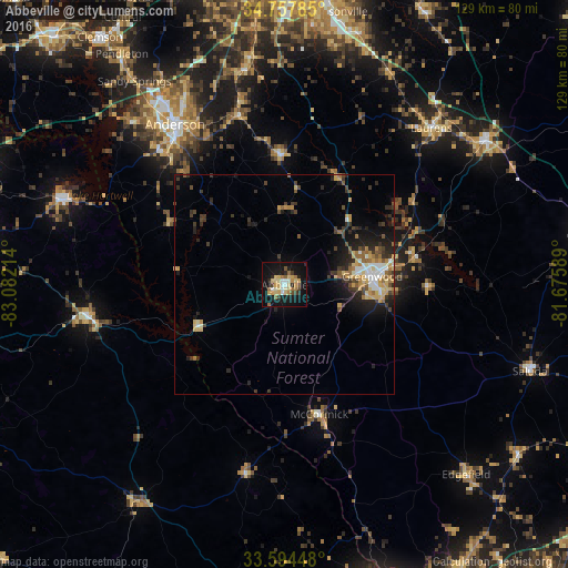
Analysis of Abbeville night lights 2016
Square area 10x10 km:
 3.11%
3.11%90-99
4.21%80-89
10.81%70-79
4.58%60-69
4.95%50-59
2.75%40-49
2.2%30-39
3.11%20-29
4.76%10-19
39.74%0-9
19.78%Square area 50x50 km:
0.83%90-99
0.87%80-89
1.45%70-79
1.16%60-69
0.93%50-59
0.84%40-49
1.06%30-39
1.65%20-29
2.28%10-19
5.15%0-9
83.77%Clear (daylight) street map image can be seen on geolist.org.
Map coordinates:
34° 45' 28.3" North, 83° 4' 55.7" West
34° 10' 41.4" North, 82° 22' 44.4" West
33° 35' 40.1" North, 81° 40' 33.2" West
Some cities around Abbeville sort by population:
• Anderson
43.9 km =27.3 mi,  325°
325°
• Greenwood
20.1 km =12.5 mi,  84°
84°
• Laurens
48.9 km =30.4 mi,  43°
43°
• Clinton
56.3 km =35 mi,  54°
54°
• Fountain Inn
59.2 km =36.8 mi,  16°
16°
• Centerville
49.4 km =30.7 mi,  322°
322°
• Homeland Park
42.1 km =26.2 mi, 320°
• Piedmont
58.8 km =36.5 mi,  352°
352°
4568985 (p: 5,191)
Sources (retrieved 2019-11-25):
» Earth at Night: Flat Maps 2012, 2016