Uspenka night lights from space
Night Light of Uspenka (Luhansk) from space (Ukraine) Src. Average luminocity for 10x10km area is 1.8168% and for 50x50km: 1.9722%.
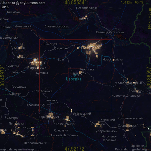
Analysis of Uspenka night lights 2016
Square area 10x10 km:
 0%
0%90-99
0%80-89
0%70-79
0.28%60-69
0.85%50-59
0.57%40-49
0.57%30-39
0.57%20-29
0%10-19
0%0-9
97.16%Square area 50x50 km:
0.02%90-99
0.04%80-89
0.21%70-79
0.13%60-69
0.58%50-59
0.51%40-49
0.56%30-39
0.39%20-29
0.46%10-19
1.54%0-9
95.55%Clear (daylight) street map image can be seen on geolist.org.
Map coordinates:
48° 51' 19.9" North, 38° 27' 35" East
48° 23' 26.8" North, 39° 9' 46.2" East
47° 55' 18.2" North, 39° 51' 57.5" East
Some cities around Uspenka sort by population:
• Luhansk
22.7 km =14.1 mi,  30°
30°
• Alchevs’k
27 km =16.8 mi,  288°
288°
• Pereval’s’k
24.1 km =15 mi,  282°
282°
• Lutuhyne
5 km =3.1 mi,  71°
71°
• Zymohiria
27.3 km =17 mi,  322°
322°
• Bile
14.3 km =8.9 mi, 324°
• Rozkishne
13.9 km =8.6 mi,  37°
37°
• Teple
30.8 km =19.1 mi,  106°
106°
690629 (p: 9,400)
Sources (retrieved 2019-11-25):
» Earth at Night: Flat Maps 2012, 2016