Lyubymivka night lights from space
Night Light of Lyubymivka (Kherson) from space (Ukraine) Src. Average luminocity for 10x10km area is 1.8244% and for 50x50km: 1.3271%.
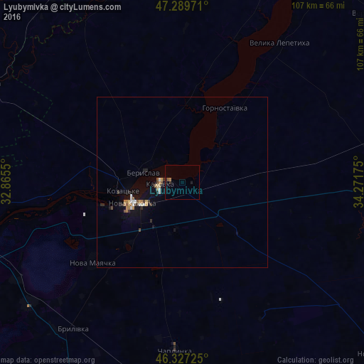
Analysis of Lyubymivka night lights 2016
Square area 10x10 km:
 0%
0%90-99
0%80-89
0%70-79
0%60-69
0.6%50-59
0.6%40-49
0%30-39
0.6%20-29
1.19%10-19
0.6%0-9
96.43%Square area 50x50 km:
0.09%90-99
0.21%80-89
0.09%70-79
0.18%60-69
0.23%50-59
0.16%40-49
0.14%30-39
0.19%20-29
0.21%10-19
0.86%0-9
97.65%Clear (daylight) street map image can be seen on geolist.org.
Map coordinates:
47° 17' 23" North, 32° 51' 55.8" East
46° 48' 38.3" North, 33° 34' 7" East
46° 19' 38.1" North, 34° 16' 18.3" East
Some cities around Lyubymivka sort by population:
• Nova Kakhovka
17.9 km =11.1 mi,  249°
249°
• Kakhovka
6.2 km =3.9 mi,  273°
273°
• Beryslav
11.2 km =7 mi,  287°
287°
• Chaplynka
49.6 km =30.8 mi,  182°
182°
• Velyka Lepetykha
49.6 km =30.8 mi,  35°
35°
• Nova Mayachka
35 km =21.7 mi,  228°
228°
• Hornostayivka
25.1 km =15.6 mi,  29°
29°
• Velyki Kopani
57.9 km =36 mi, 231°
702459 (p: 5,786)
Sources (retrieved 2019-11-25):
» Earth at Night: Flat Maps 2012, 2016