Chaplynka night lights from space
Night Light of Chaplynka (Kherson) from space (Ukraine) Src. Average luminocity for 10x10km area is 0.7708% and for 50x50km: 0.2454%.
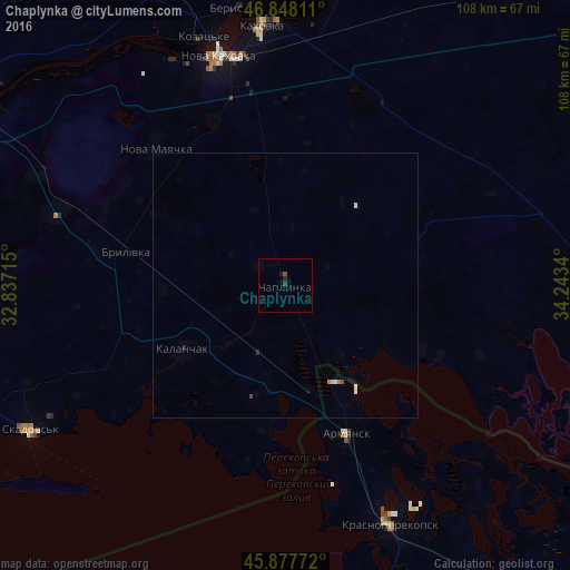
Analysis of Chaplynka night lights 2016
Square area 10x10 km:
 0%
0%90-99
0%80-89
0%70-79
0%60-69
0%50-59
0%40-49
0.6%30-39
0.6%20-29
0.3%10-19
0.89%0-9
97.62%Square area 50x50 km:
0.01%90-99
0.08%80-89
0.02%70-79
0.02%60-69
0.03%50-59
0%40-49
0.07%30-39
0.02%20-29
0.06%10-19
0.04%0-9
99.64%Clear (daylight) street map image can be seen on geolist.org.
Map coordinates:
46° 50' 53.2" North, 32° 50' 13.7" East
46° 21' 54.3" North, 33° 32' 25" East
45° 52' 39.8" North, 34° 14' 36.2" East
Some cities around Chaplynka sort by population:
• Nova Kakhovka
45.7 km =28.4 mi,  341°
341°
• Kakhovka
50.1 km =31.1 mi,  355°
355°
• Krasnoperekops’k
49.5 km =30.8 mi,  156°
156°
• Armyansk
30.8 km =19.1 mi, 157°
• Kalanchak
22.7 km =14.1 mi,  237°
237°
• Nova Mayachka
35.5 km =22.1 mi,  317°
317°
• Lyubymivka
49.6 km =30.8 mi,  2°
2°
• Velyki Kopani
45.4 km =28.2 mi,  287°
287°
710935 (p: 10,224)
Sources (retrieved 2019-11-25):
» Earth at Night: Flat Maps 2012, 2016