Hola Prystan’ night lights from space
Night Light of Hola Prystan’ (Kherson) from space (Ukraine) Src. Average luminocity for 10x10km area is 1.9858% and for 50x50km: 3.5852%.
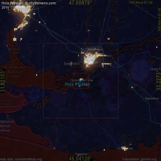
Analysis of Hola Prystan’ night lights 2016
Square area 10x10 km:
 0%
0%90-99
0%80-89
0%70-79
0%60-69
1.14%50-59
0%40-49
1.14%30-39
0%20-29
1.14%10-19
0.57%0-9
96.02%Square area 50x50 km:
0.47%90-99
0.72%80-89
0.49%70-79
0.21%60-69
0.6%50-59
0.31%40-49
0.4%30-39
0.24%20-29
1.29%10-19
2.91%0-9
92.35%Clear (daylight) street map image can be seen on geolist.org.
Map coordinates:
47° 0' 31.6" North, 31° 49' 15.8" East
46° 31' 37.9" North, 32° 31' 27" East
46° 2' 28.6" North, 33° 13' 38.3" East
Some cities around Hola Prystan’ sort by population:
• Kherson
16 km =9.9 mi,  26°
26°
• Tsyurupyns’k
18 km =11.2 mi,  55°
55°
• Bilozerka
12.5 km =7.8 mi,  330°
330°
• Chornobayivka
18.7 km =11.6 mi,  6°
6°
• Komyshany
12.3 km =7.6 mi,  353°
353°
• Oleksandrivka
39 km =24.2 mi, 27°
• Novofedorivka
42.6 km =26.5 mi,  201°
201°
• Velyki Kopani
34.8 km =21.6 mi,  97°
97°
708632 (p: 16,102)
Sources (retrieved 2019-11-25):
» Earth at Night: Flat Maps 2012, 2016