Yeşilyurt night lights from space
Night Light of Yeşilyurt (Malatya) from space (Turkey) Src. Average luminocity for 10x10km area is 49.2364% and for 50x50km: 13.246%.
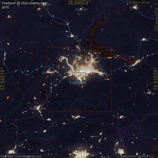
Analysis of Yeşilyurt night lights 2016
Square area 10x10 km:
 7.82%
7.82%90-99
14.63%80-89
10.03%70-79
6.29%60-69
2.55%50-59
4.76%40-49
2.89%30-39
3.57%20-29
16.33%10-19
19.56%0-9
11.56%Square area 50x50 km:
1.21%90-99
2.57%80-89
1.74%70-79
1.94%60-69
1.2%50-59
1.86%40-49
2.22%30-39
2.84%20-29
4.14%10-19
7.49%0-9
72.79%Clear (daylight) street map image can be seen on geolist.org.
Map coordinates:
38° 50' 44.7" North, 37° 32' 31.7" East
38° 17' 45.7" North, 38° 14' 42.9" East
37° 44' 31.6" North, 38° 56' 54.2" East
Some cities around Yeşilyurt sort by population:
• Malatya
8.7 km =5.4 mi,  45°
45°
• Adıyaman
59.2 km =36.8 mi,  177°
177°
• Baskil
58.3 km =36.2 mi,  58°
58°
• Doğanşehir
40.2 km =25 mi,  234°
234°
• Akçadağ
24.5 km =15.2 mi,  281°
281°
• Çelikhan
30.1 km =18.7 mi, 181°
• Sincik
43.2 km =26.8 mi,  131°
131°
• Yazıhan
33.6 km =20.9 mi,  349°
349°
296791 (p: 13,766)
Sources (retrieved 2019-11-25):
» Earth at Night: Flat Maps 2012, 2016