Yeşilli night lights from space
Night Light of Yeşilli (Mardin) from space (Turkey) Src. Average luminocity for 10x10km area is 24.8279% and for 50x50km: 10.3151%.
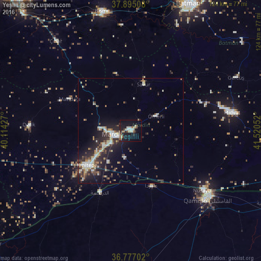

Analysis of Yeşilli night lights 2016
Square area 10x10 km:
 2.11%
2.11%90-99
5.68%80-89
4.22%70-79
0%60-69
3.9%50-59
2.92%40-49
1.79%30-39
1.95%20-29
4.87%10-19
35.55%0-9
37.01%Square area 50x50 km:
1.18%90-99
1.95%80-89
1.31%70-79
0.79%60-69
1.14%50-59
1.16%40-49
1.63%30-39
1.76%20-29
4.21%10-19
7.18%0-9
77.7%Clear (daylight) street map image can be seen on geolist.org.
Map coordinates:
37° 53' 42.3" North, 40° 6' 51.4" East
37° 20' 17.3" North, 40° 49' 2.6" East
36° 46' 37.3" North, 41° 31' 13.9" East
Some cities around Yeşilli sort by population:
• Kızıltepe
27 km =16.8 mi,  231°
231°
• Mardin
7.1 km =4.4 mi,  246°
246°
• Ad Darbāsīyah, SY
32.9 km =20.4 mi,  206°
206°
• Kabala
1.7 km =1.1 mi,  300°
300°
• Savur
22.6 km =14 mi,  13°
13°
• Ömerli
13.9 km =8.6 mi,  60°
60°
• Akarsu
24.2 km =15 mi,  121°
121°
• Ortaköy
13.4 km =8.3 mi,  192°
192°
296832 (p: 32,072)
Sources (retrieved 2019-11-25):
» Earth at Night: Flat Maps 2012, 2016