Uluborlu night lights from space
Night Light of Uluborlu (Isparta) from space (Turkey) Src. Average luminocity for 10x10km area is 6.8068% and for 50x50km: 5.4393%.
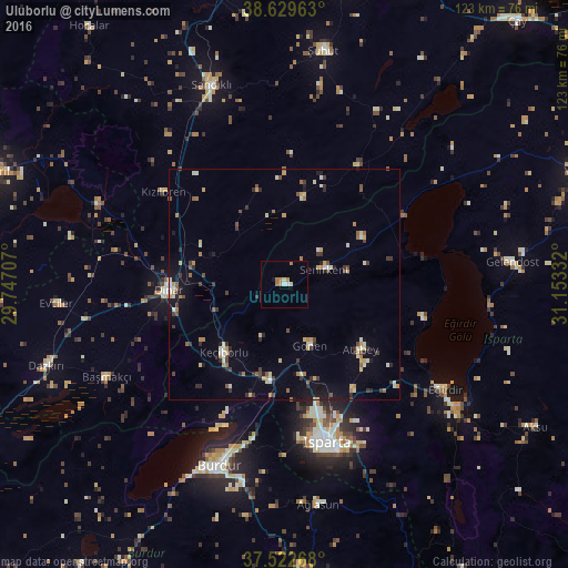
Analysis of Uluborlu night lights 2016
Square area 10x10 km:
 0%
0%90-99
1.79%80-89
0.81%70-79
1.46%60-69
2.44%50-59
0%40-49
0%30-39
0%20-29
0%10-19
1.3%0-9
92.21%Square area 50x50 km:
0.13%90-99
1.02%80-89
0.7%70-79
0.73%60-69
0.74%50-59
0.5%40-49
0.63%30-39
1.09%20-29
0.75%10-19
1.98%0-9
91.71%Clear (daylight) street map image can be seen on geolist.org.
Map coordinates:
38° 37' 46.7" North, 29° 44' 49.5" East
38° 4' 41.7" North, 30° 27' 0.7" East
37° 31' 21.6" North, 31° 9' 12" East
Some cities around Uluborlu sort by population:
• Isparta
36 km =22.4 mi,  165°
165°
• Burdur
42.2 km =26.2 mi,  199°
199°
• Dinar
25 km =15.5 mi,  266°
266°
• Eğirdir
41.8 km =26 mi,  122°
122°
• Senirkent
9.1 km =5.7 mi,  71°
71°
• Gönen
14.6 km =9.1 mi,  158°
158°
• Atabey
21.8 km =13.5 mi,  130°
130°
• Keçiborlu
19.9 km =12.4 mi,  220°
220°
298451 (p: 12,514)
Sources (retrieved 2019-11-25):
» Earth at Night: Flat Maps 2012, 2016