Senirkent night lights from space
Night Light of Senirkent (Isparta) from space (Turkey) Src. Average luminocity for 10x10km area is 9.211% and for 50x50km: 4.3015%.
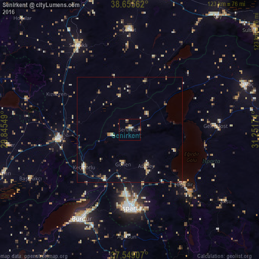
Analysis of Senirkent night lights 2016
Square area 10x10 km:
 1.14%
1.14%90-99
1.46%80-89
0.81%70-79
1.46%60-69
0.97%50-59
0.49%40-49
1.46%30-39
2.11%20-29
1.14%10-19
0.97%0-9
87.99%Square area 50x50 km:
0.11%90-99
0.81%80-89
0.56%70-79
0.64%60-69
0.52%50-59
0.42%40-49
0.5%30-39
0.95%20-29
0.66%10-19
0.66%0-9
94.15%Clear (daylight) street map image can be seen on geolist.org.
Map coordinates:
38° 39' 20.2" North, 29° 50' 43.8" East
38° 6' 16" North, 30° 32' 55" East
37° 32' 56.7" North, 31° 15' 6.3" East
Some cities around Senirkent sort by population:
• Isparta
37.8 km =23.5 mi,  179°
179°
• Dinar
33.8 km =21 mi,  262°
262°
• Eğirdir
36.8 km =22.9 mi,  134°
134°
• Gönen
16.8 km =10.4 mi,  191°
191°
• Atabey
18.8 km =11.7 mi,  155°
155°
• Uluborlu
9.1 km =5.7 mi,  251°
251°
• Keçiborlu
28.1 km =17.5 mi,  230°
230°
• Gelendost
40.9 km =25.4 mi,  87°
87°
301172 (p: 15,919)
Sources (retrieved 2019-11-25):
» Earth at Night: Flat Maps 2012, 2016