Tomarza night lights from space
Night Light of Tomarza (Kayseri) from space (Turkey) Src. Average luminocity for 10x10km area is 9.7695% and for 50x50km: 3.2019%.
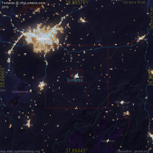
Analysis of Tomarza night lights 2016
Square area 10x10 km:
 0%
0%90-99
3.9%80-89
0.65%70-79
1.3%60-69
1.3%50-59
0%40-49
1.95%30-39
0.65%20-29
1.3%10-19
0%0-9
88.96%Square area 50x50 km:
0.04%90-99
0.42%80-89
0.27%70-79
0.48%60-69
0.48%50-59
0.64%40-49
0.58%30-39
0.81%20-29
1.21%10-19
1.62%0-9
93.45%Clear (daylight) street map image can be seen on geolist.org.
Map coordinates:
38° 59' 44.8" North, 35° 5' 45.8" East
38° 26' 50" North, 35° 47' 57" East
37° 53' 40" North, 36° 30' 8.3" East
Some cities around Tomarza sort by population:
• Kayseri
41.8 km =26 mi,  319°
319°
• Talas
34.5 km =21.4 mi, 321°
• Develi
27.5 km =17.1 mi,  256°
256°
• Yahyalı
54.4 km =33.8 mi,  225°
225°
• Hacılar
37.6 km =23.4 mi,  306°
306°
• Bünyan
44.7 km =27.8 mi,  6°
6°
• Saimbeyli
57.2 km =35.5 mi,  153°
153°
• Tufanbeyli
42 km =26.1 mi,  119°
119°
299054 (p: 11,753)
Sources (retrieved 2019-11-25):
» Earth at Night: Flat Maps 2012, 2016