Şuhut night lights from space
Night Light of Şuhut (Afyonkarahisar) from space (Turkey) Src. Average luminocity for 10x10km area is 17.1997% and for 50x50km: 7.8232%.
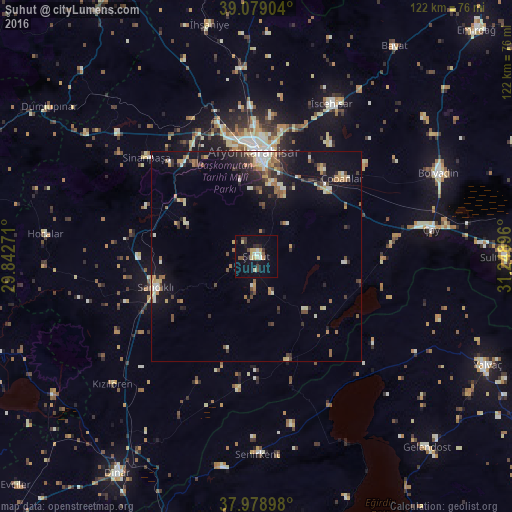
Analysis of Şuhut night lights 2016
Square area 10x10 km:
 1.3%
1.3%90-99
2.92%80-89
2.92%70-79
2.27%60-69
0.32%50-59
1.95%40-49
2.44%30-39
2.6%20-29
2.11%10-19
12.82%0-9
68.34%Square area 50x50 km:
0.34%90-99
1.44%80-89
0.93%70-79
0.92%60-69
1.16%50-59
0.81%40-49
1.3%30-39
1.17%20-29
1.92%10-19
5.42%0-9
84.59%Clear (daylight) street map image can be seen on geolist.org.
Map coordinates:
39° 4' 44.5" North, 29° 50' 33.8" East
38° 31' 52" North, 30° 32' 45" East
37° 58' 44.3" North, 31° 14' 56.3" East
Some cities around Şuhut sort by population:
• Afyonkarahisar
25.1 km =15.6 mi,  359°
359°
• Bolvadin
48 km =29.8 mi,  65°
65°
• Sandıklı
25.2 km =15.7 mi,  252°
252°
• Çay
42.5 km =26.4 mi,  80°
80°
• Senirkent
47.4 km =29.5 mi,  179°
179°
• İscehisar
40.8 km =25.4 mi,  25°
25°
• Işıklar
23 km =14.3 mi,  47°
47°
• Sinanpaşa
35.4 km =22 mi,  312°
312°
300273 (p: 13,842)
Sources (retrieved 2019-11-25):
» Earth at Night: Flat Maps 2012, 2016