Gelendost night lights from space
Night Light of Gelendost (Isparta) from space (Turkey) Src. Average luminocity for 10x10km area is 14.2711% and for 50x50km: 4.485%.
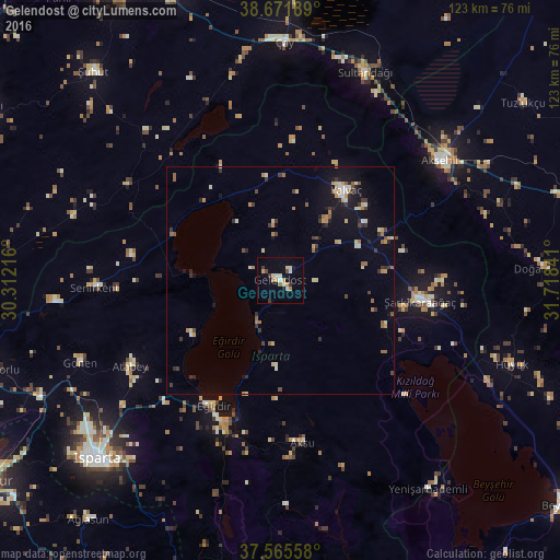
Analysis of Gelendost night lights 2016
Square area 10x10 km:
 0.81%
0.81%90-99
4.38%80-89
0.65%70-79
2.6%60-69
1.95%50-59
0%40-49
1.3%30-39
2.6%20-29
0.16%10-19
2.27%0-9
83.28%Square area 50x50 km:
0.13%90-99
0.88%80-89
0.48%70-79
0.55%60-69
0.68%50-59
0.55%40-49
0.4%30-39
0.93%20-29
0.68%10-19
2.3%0-9
92.41%Clear (daylight) street map image can be seen on geolist.org.
Map coordinates:
38° 40' 18.8" North, 30° 18' 43.8" East
38° 7' 15" North, 31° 0' 55" East
37° 33' 56.1" North, 31° 43' 6.3" East
Some cities around Gelendost sort by population:
• Akşehir
43.8 km =27.2 mi,  53°
53°
• Yalvaç
24.1 km =15 mi,  36°
36°
• Şarkîkaraağaç
31.1 km =19.3 mi,  98°
98°
• Eğirdir
31 km =19.3 mi,  207°
207°
• Senirkent
40.9 km =25.4 mi,  267°
267°
• Gönen
47.8 km =29.7 mi,  247°
247°
• Atabey
38 km =23.6 mi,  240°
240°
• Sultandağı
49.2 km =30.6 mi,  22°
22°
314698 (p: 7,274)
Sources (retrieved 2019-11-25):
» Earth at Night: Flat Maps 2012, 2016