Sarayönü night lights from space
Night Light of Sarayönü (Konya) from space (Turkey) Src. Average luminocity for 10x10km area is 13.2245% and for 50x50km: 3.3346%.
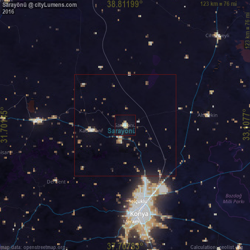
Analysis of Sarayönü night lights 2016
Square area 10x10 km:
 1.53%
1.53%90-99
1.36%80-89
2.55%70-79
2.38%60-69
1.02%50-59
0.68%40-49
0%30-39
0.68%20-29
0.17%10-19
12.93%0-9
76.7%Square area 50x50 km:
0.15%90-99
0.4%80-89
0.42%70-79
0.3%60-69
0.48%50-59
0.49%40-49
0.49%30-39
0.71%20-29
0.61%10-19
2.11%0-9
93.83%Clear (daylight) street map image can be seen on geolist.org.
Map coordinates:
38° 48' 43.2" North, 31° 42' 5.2" East
38° 15' 43.2" North, 32° 24' 16.5" East
37° 42' 28.2" North, 33° 6' 27.7" East
Some cities around Sarayönü sort by population:
• Konya
44 km =27.3 mi,  170°
170°
• Ilgın
42.9 km =26.7 mi,  272°
272°
• Kadınhanı
17 km =10.6 mi,  261°
261°
• Cihanbeyli
63.4 km =39.4 mi,  45°
45°
• Altınekin
40.8 km =25.4 mi,  82°
82°
• Doğanhisar
64.9 km =40.3 mi, 258°
• Derbent
43.7 km =27.2 mi,  230°
230°
• Tuzlukçu
72 km =44.7 mi,  289°
289°
301824 (p: 10,198)
Sources (retrieved 2019-11-25):
» Earth at Night: Flat Maps 2012, 2016