Kadınhanı night lights from space
Night Light of Kadınhanı (Konya) from space (Turkey) Src. Average luminocity for 10x10km area is 12.5646% and for 50x50km: 3.8127%.
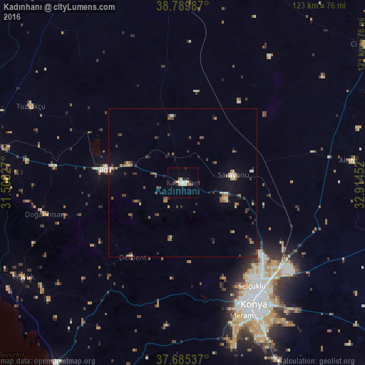
Analysis of Kadınhanı night lights 2016
Square area 10x10 km:
 2.21%
2.21%90-99
2.04%80-89
2.04%70-79
1.19%60-69
0.68%50-59
1.36%40-49
0.34%30-39
2.04%20-29
1.36%10-19
1.36%0-9
85.37%Square area 50x50 km:
0.15%90-99
0.41%80-89
0.43%70-79
0.41%60-69
0.56%50-59
0.65%40-49
0.6%30-39
1.04%20-29
0.64%10-19
1.79%0-9
93.32%Clear (daylight) street map image can be seen on geolist.org.
Map coordinates:
38° 47' 23.5" North, 31° 30' 29.8" East
38° 14' 23" North, 32° 12' 41" East
37° 41' 7.3" North, 32° 54' 52.3" East
Some cities around Kadınhanı sort by population:
• Konya
47.4 km =29.5 mi,  149°
149°
• Ilgın
26.3 km =16.3 mi,  279°
279°
• Altınekin
57.9 km =36 mi,  82°
82°
• Hüyük
62.5 km =38.8 mi,  239°
239°
• Sarayönü
17 km =10.6 mi, 81°
• Doğanhisar
47.9 km =29.8 mi,  257°
257°
• Derbent
30.3 km =18.8 mi,  214°
214°
• Tuzlukçu
57.5 km =35.7 mi,  297°
297°
310907 (p: 15,301)
Sources (retrieved 2019-11-25):
» Earth at Night: Flat Maps 2012, 2016