Mazıdağı night lights from space
Night Light of Mazıdağı (Mardin) from space (Turkey) Src. Average luminocity for 10x10km area is 8.0341% and for 50x50km: 5.3536%.
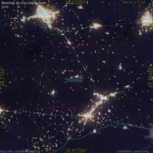
Analysis of Mazıdağı night lights 2016
Square area 10x10 km:
 0.97%
0.97%90-99
1.62%80-89
0%70-79
0.81%60-69
2.44%50-59
1.3%40-49
0.65%30-39
1.3%20-29
0.32%10-19
1.3%0-9
89.29%Square area 50x50 km:
0.59%90-99
1.03%80-89
0.62%70-79
0.38%60-69
0.67%50-59
0.73%40-49
0.81%30-39
0.93%20-29
2.04%10-19
2.64%0-9
89.56%Clear (daylight) street map image can be seen on geolist.org.
Map coordinates:
38° 2' 2.1" North, 39° 46' 42.2" East
37° 28' 40.8" North, 40° 28' 53.5" East
36° 55' 4.6" North, 41° 11' 4.7" East
Some cities around Mazıdağı sort by population:
• Kızıltepe
33.3 km =20.7 mi,  165°
165°
• Mardin
29.5 km =18.3 mi,  128°
128°
• Yeşilli
33.5 km =20.8 mi,  117°
117°
• Kabala
31.8 km =19.8 mi, 117°
• Savur
35.6 km =22.1 mi,  79°
79°
• Ömerli
42.7 km =26.5 mi,  101°
101°
• Ortaköy
39.2 km =24.4 mi,  136°
136°
• Ambar
41.9 km =26 mi,  5°
5°
304734 (p: 13,138)
Sources (retrieved 2019-11-25):
» Earth at Night: Flat Maps 2012, 2016