Kumburgaz night lights from space
Night Light of Kumburgaz (Istanbul) from space (Turkey) Src. Average luminocity for 10x10km area is 47.7024% and for 50x50km: 22.4812%.
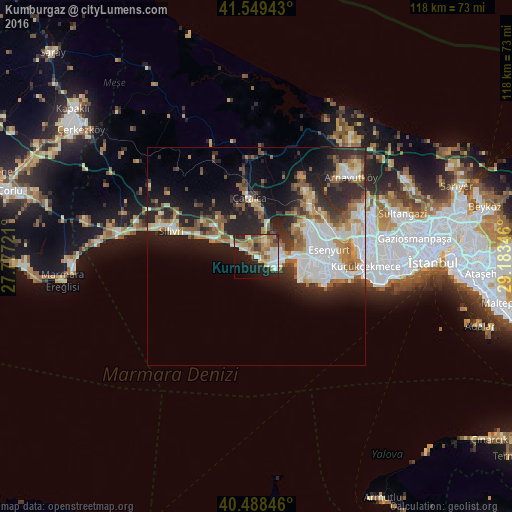
Analysis of Kumburgaz night lights 2016
Square area 10x10 km:
 6.12%
6.12%90-99
8.84%80-89
7.31%70-79
9.01%60-69
8.16%50-59
10.03%40-49
4.42%30-39
2.21%20-29
12.93%10-19
21.43%0-9
9.52%Square area 50x50 km:
4.71%90-99
4.46%80-89
2.02%70-79
2.3%60-69
3.21%50-59
3.71%40-49
1.92%30-39
3.01%20-29
7.62%10-19
11.04%0-9
56%Clear (daylight) street map image can be seen on geolist.org.
Map coordinates:
41° 32' 57.9" North, 27° 46' 38" East
41° 1' 15.9" North, 28° 28' 49.2" East
40° 29' 18.5" North, 29° 11' 0.5" East
Some cities around Kumburgaz sort by population:
• Büyükçekmece
8.8 km =5.5 mi,  90°
90°
• Beylikdüzü
14.1 km =8.8 mi,  107°
107°
• Mimarsinan
6.8 km =4.2 mi, 92°
• Gürpınar
11.7 km =7.3 mi, 105°
• Tepecik
5.9 km =3.7 mi,  81°
81°
• Çatalca
13.7 km =8.5 mi,  353°
353°
• Selimpaşa
10.2 km =6.3 mi,  291°
291°
• Celâliye
6.2 km =3.9 mi,  303°
303°
742266 (p: 11,949)
Sources (retrieved 2019-11-25):
» Earth at Night: Flat Maps 2012, 2016