Celâliye night lights from space
Night Light of Celâliye (Istanbul) from space (Turkey) Src. Average luminocity for 10x10km area is 37.4626% and for 50x50km: 19.0954%.
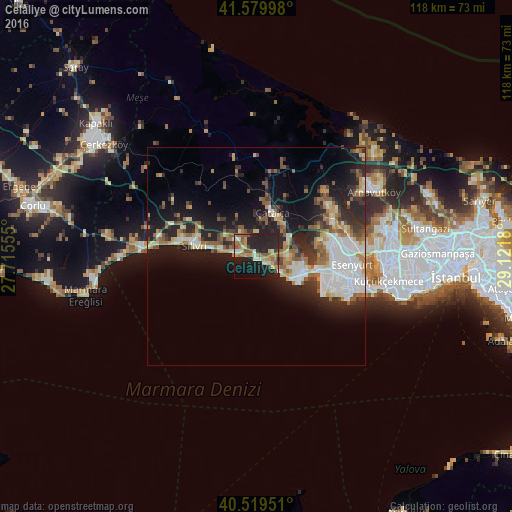
Analysis of Celâliye night lights 2016
Square area 10x10 km:
 2.21%
2.21%90-99
5.78%80-89
4.59%70-79
7.14%60-69
6.29%50-59
9.52%40-49
2.04%30-39
1.02%20-29
21.26%10-19
33.16%0-9
6.97%Square area 50x50 km:
3.67%90-99
3.4%80-89
1.8%70-79
1.95%60-69
2.5%50-59
3.45%40-49
1.59%30-39
2.71%20-29
6.53%10-19
12.17%0-9
60.24%Clear (daylight) street map image can be seen on geolist.org.
Map coordinates:
41° 34' 47.9" North, 27° 42' 56" East
41° 3' 6.8" North, 28° 25' 7.2" East
40° 31' 10.2" North, 29° 7' 18.5" East
Some cities around Celâliye sort by population:
• Büyükçekmece
14.4 km =8.9 mi,  103°
103°
• Silivri
14.6 km =9.1 mi,  279°
279°
• Kavaklı
8.6 km =5.3 mi,  301°
301°
• Mimarsinan
12.6 km =7.8 mi,  107°
107°
• Tepecik
11.3 km =7 mi, 102°
• Çatalca
10.8 km =6.7 mi,  19°
19°
• Kumburgaz
6.2 km =3.9 mi,  123°
123°
• Selimpaşa
4.4 km =2.7 mi,  273°
273°
857229 (p: 7,788)
Sources (retrieved 2019-11-25):
» Earth at Night: Flat Maps 2012, 2016