İncirliova night lights from space
Night Light of İncirliova (Aydın) from space (Turkey) Src. Average luminocity for 10x10km area is 40.2484% and for 50x50km: 13.3215%.
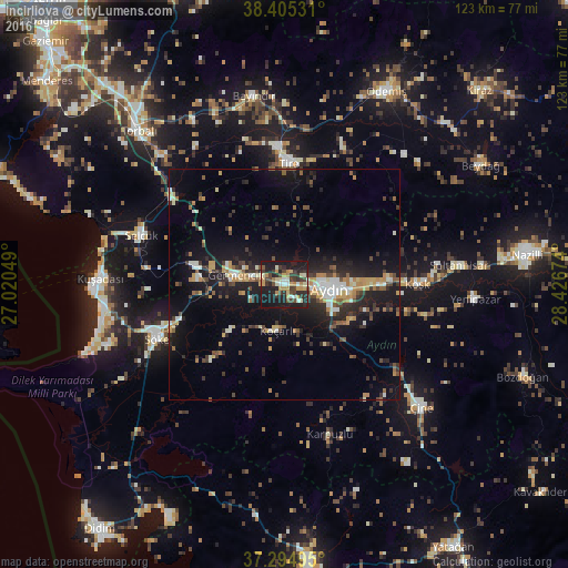
Analysis of İncirliova night lights 2016
Square area 10x10 km:
100  2.6%
2.6%
90-99 7.14%
80-89 6.01%
70-79 7.31%
60-69 4.55%
50-59 1.62%
40-49 7.47%
30-39 11.69%
20-29 15.58%
10-19 36.04%
0-9 0%
2.6%90-99
7.14%80-89
6.01%70-79
7.31%60-69
4.55%50-59
1.62%40-49
7.47%30-39
11.69%20-29
15.58%10-19
36.04%0-9
0%Square area 50x50 km:
100 1.01%
90-99 2.03%
80-89 1.14%
70-79 2.06%
60-69 1.52%
50-59 1.27%
40-49 2.17%
30-39 2.33%
20-29 4.49%
10-19 12.58%
0-9 69.4%
1.01%90-99
2.03%80-89
1.14%70-79
2.06%60-69
1.52%50-59
1.27%40-49
2.17%30-39
2.33%20-29
4.49%10-19
12.58%0-9
69.4%Clear (daylight) street map image can be seen on geolist.org.
Map coordinates:
38° 24' 19.1" North, 27° 1' 13.8" East
37° 51' 8" North, 27° 43' 25" East
37° 17' 41.8" North, 28° 25' 36.3" East
Some cities around İncirliova sort by population:
• Aydın
10.2 km =6.3 mi,  94°
94°
• Söke
30.2 km =18.8 mi,  247°
247°
• Tire
26.3 km =16.3 mi,  2°
2°
• Selçuk
33 km =20.5 mi,  289°
289°
• Germencik
10.8 km =6.7 mi,  280°
280°
• Acarlar
3.7 km =2.3 mi,  146°
146°
• Köşk
28.8 km =17.9 mi, 89°
• Koçarlı
10.2 km =6.3 mi,  188°
188°
311314 (p: 18,572)
Sources (retrieved 2019-11-25):
» Earth at Night: Flat Maps 2012, 2016