Kocaköy night lights from space
Night Light of Kocaköy (Diyarbakır) from space (Turkey) Src. Average luminocity for 10x10km area is 12.1327% and for 50x50km: 3.2538%.
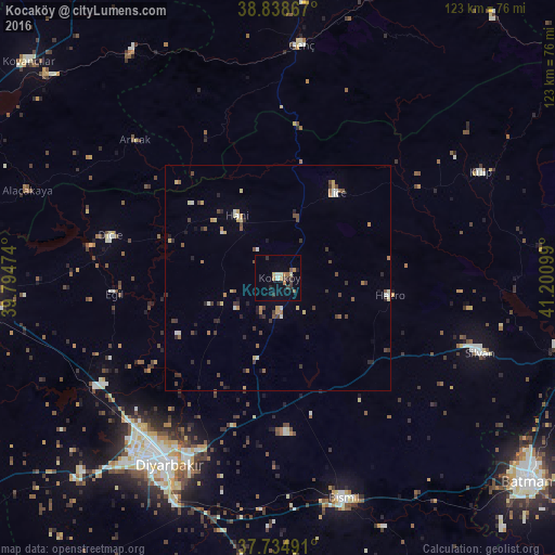
Analysis of Kocaköy night lights 2016
Square area 10x10 km:
 0%
0%90-99
1.87%80-89
1.36%70-79
1.53%60-69
2.38%50-59
1.19%40-49
2.04%30-39
3.06%20-29
2.21%10-19
1.19%0-9
83.16%Square area 50x50 km:
0.11%90-99
0.49%80-89
0.42%70-79
0.4%60-69
0.41%50-59
0.37%40-49
0.77%30-39
0.8%20-29
0.82%10-19
0.33%0-9
95.09%Clear (daylight) street map image can be seen on geolist.org.
Map coordinates:
38° 50' 19.2" North, 39° 47' 41.1" East
38° 17' 20" North, 40° 29' 52.3" East
37° 44' 5.7" North, 41° 12' 3.6" East
Some cities around Kocaköy sort by population:
• Diyarbakır
48.4 km =30.1 mi,  210°
210°
• Silvan
47.7 km =29.6 mi,  110°
110°
• Lice
22.5 km =14 mi,  33°
33°
• Dicle
38.8 km =24.1 mi,  282°
282°
• Hani
16.4 km =10.2 mi,  323°
323°
• Hazro
24.3 km =15.1 mi,  100°
100°
• Arıcak
44.6 km =27.7 mi,  313°
313°
• Ambar
48.5 km =30.1 mi,  176°
176°
306935 (p: 6,485)
Sources (retrieved 2019-11-25):
» Earth at Night: Flat Maps 2012, 2016